Shuangling geodata
Shuangling (Zhejiang) is a seat of a fourth-order administrative division; located in China in Asia/Shanghai (GMT+8) time zone. In our database, there are 1268 cities with bigger population. Compared to other cities in China, 73.9% of cities are located further ↑North; 85.7% of cities are located further ←West and 87.7% of cities have higher elevation than Shuangling. Note1


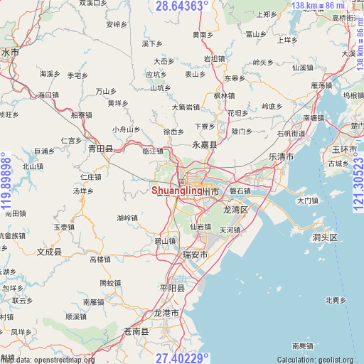
Shuangling GPS coordinates[2]
28° 1' 29.1" North, 120° 36' 7.56" East
| Map corner | latitude | longitude |
|---|---|---|
| Upper-left | 28.64363°, | 119.89898° |
| Center: | 28.02475°, | 120.6021° |
| Lower-right: | 27.40229°, | 121.30523° |
| Map W x H: | 138×138 km | = 85.7×85.7mi |
| max Lat: | 53.31946° ⇑73.9% North |
| Shuangling: | 28.02475° |
| min Lat: | ⇓26.1% South 18.22056° |
| min Long | Shuangling | max Long |
| 75.07348° | 120.6021° | 134.28917° |
| W 85.7%⇐ | ⇒14.3% E |
Elevation
Elevation of Shuangling is 12 m = 39 ft, and this is 472.8 m = 1551 ft below average elevation for this country.
| Max E: |
5622 m = 18445 ft | 87.7% |
| Avg. | 484.8 m = 1591 ft | |
| Shuangling | 12 m = 39 ft | |
Min E: |
-3 m = -10 ft | 12.3% |
See also: China elevation on elevation.city.
Geographical zone
Shuangling is located in North temperate zone (between Tropic of Cancer and the Arctic Circle). Distance of this Northern Tropic circle is 510.1 km =317 mi to South.| Distance of | km | miles | from Shuangling |
|---|---|---|---|
| North Pole | 6891 | 4281.9 | to North |
| Arctic Circle | 4285.1 | 2662.6 | to North |
| Tropic Cancer | 510.1 | 317 | to South |
| Equator | 3116.1 | 1936.3 | to South |


Nearby cities:
15 places around Shuangling: (largest is in red/bold)
• Linjiang
16.5 km =10.3 mi,  316°
316°
• Louqiao
3.3 km =2.1 mi,  118°
118°
• Oubei
5.6 km =3.5 mi,  63°
63°
• Qiaotou
20.5 km =12.7 mi, 322°
• Qiaoxia
16.7 km =10.4 mi,  344°
344°
• Qidu
16 km =9.9 mi,  96°
96°
• Shangtang
16.8 km =10.4 mi,  30°
30°
• Shiqiao
6.4 km =4 mi,  221°
221°
• Shuangchao
20.1 km =12.5 mi,  309°
309°
• Shuangyu
0.8 km =0.5 mi,  146°
146°
• Tengqiao
11.2 km =7 mi,  296°
296°
• Wenzhou
6.9 km =4.3 mi,  113°
113°
• Wuma
6.3 km =3.9 mi, 97°
• Wuniu
18.6 km =11.6 mi,  85°
85°
• Xu’ao
19.7 km =12.2 mi,  350°
350°
Sources, notices
• [Note1] Compared only with cities in China existing in our database
• [Src1] Map data: © OpenStreetMap contributors (CC-BY-SA)
• [Src2] Other city data from geonames.org with taken over terms of usage.
• [Src3] Geographical zone / Annual Mean Temperature by Robert A. Rohde @ Wikipedia
