Wuma geodata
Wuma (Zhejiang) is a seat of a third-order administrative division; located in China in Asia/Shanghai (GMT+8) time zone. In our database, there are 1268 cities with bigger population. Compared to other cities in China, 73.9% of cities are located further ↑North; 86% of cities are located further ←West and 86.9% of cities have higher elevation than Wuma. Note1


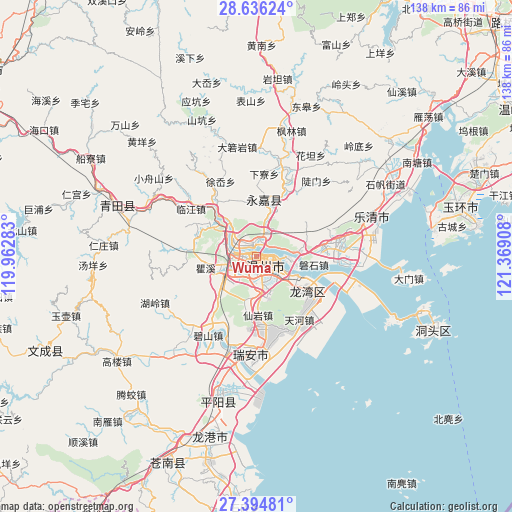
Wuma GPS coordinates[2]
28° 1' 2.316" North, 120° 39' 57.42" East
| Map corner | latitude | longitude |
|---|---|---|
| Upper-left | 28.63624°, | 119.96283° |
| Center: | 28.01731°, | 120.66595° |
| Lower-right: | 27.39481°, | 121.36908° |
| Map W x H: | 138×138 km | = 85.7×85.7mi |
| max Lat: | 53.31946° ⇑73.9% North |
| Wuma: | 28.01731° |
| min Lat: | ⇓26.1% South 18.22056° |
| min Long | Wuma | max Long |
| 75.07348° | 120.66595° | 134.28917° |
| W 86%⇐ | ⇒14% E |
Elevation
Elevation of Wuma is 13 m = 43 ft, and this is 471.8 m = 1548 ft below average elevation for this country.
| Max E: |
5622 m = 18445 ft | 86.9% |
| Avg. | 484.8 m = 1591 ft | |
| Wuma | 13 m = 43 ft | |
Min E: |
-3 m = -10 ft | 13.1% |
See also: China elevation on elevation.city.
Geographical zone
Wuma is located in North temperate zone (between Tropic of Cancer and the Arctic Circle). Distance of this Northern Tropic circle is 509.3 km =316.5 mi to South.| Distance of | km | miles | from Wuma |
|---|---|---|---|
| North Pole | 6891.8 | 4282.4 | to North |
| Arctic Circle | 4285.9 | 2663.1 | to North |
| Tropic Cancer | 509.3 | 316.5 | to South |
| Equator | 3115.2 | 1935.7 | to South |


Nearby cities:
15 places around Wuma: (largest is in red/bold)
• Baishi
21.1 km =13.1 mi,  64°
64°
• Linjiang
21.8 km =13.5 mi,  306°
306°
• Louqiao
3.4 km =2.1 mi,  257°
257°
• Oubei
3.5 km =2.2 mi,  339°
339°
• Qiaoxia
20.1 km =12.5 mi,  327°
327°
• Qidu
9.7 km =6 mi,  96°
96°
• Shangtang
15.5 km =9.6 mi,  8°
8°
• Shatou
22.1 km =13.7 mi,  23°
23°
• Shiqiao
11.2 km =7 mi,  249°
249°
• Shuangling
6.3 km =3.9 mi,  277°
277°
• Shuangyu
5.8 km =3.6 mi,  271°
271°
• Tengqiao
17.3 km =10.7 mi,  289°
289°
• Wenzhou
2 km =1.2 mi,  177°
177°
• Wuniu
12.5 km =7.8 mi,  79°
79°
• Xialiao
22.4 km =13.9 mi, 5°
Sources, notices
• [Note1] Compared only with cities in China existing in our database
• [Src1] Map data: © OpenStreetMap contributors (CC-BY-SA)
• [Src2] Other city data from geonames.org with taken over terms of usage.
• [Src3] Geographical zone / Annual Mean Temperature by Robert A. Rohde @ Wikipedia
