Wenzhou geodata
Wenzhou (Zhejiang) is a populated place; located in China in Asia/Shanghai (GMT+8) time zone. With population of 865,672 people, there are 73 cities with bigger population in this country. Compared to other cities in China, 74.1% of cities are located further ↑North; 86% of cities are located further ←West and 89.9% of cities have higher elevation than Wenzhou. Note1


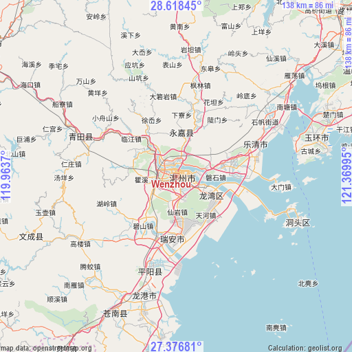
Wenzhou GPS coordinates[2]
27° 59' 57.912" North, 120° 40' 0.552" East
| Map corner | latitude | longitude |
|---|---|---|
| Upper-left | 28.61845°, | 119.9637° |
| Center: | 27.99942°, | 120.66682° |
| Lower-right: | 27.37681°, | 121.36995° |
| Map W x H: | 138.1×138.1 km | = 85.8×85.8mi |
| max Lat: | 53.31946° ⇑74.1% North |
| Wenzhou: | 27.99942° |
| min Lat: | ⇓25.9% South 18.22056° |
| min Long | Wenzhou | max Long |
| 75.07348° | 120.66682° | 134.28917° |
| W 86%⇐ | ⇒14% E |
Elevation
Elevation of Wenzhou is 10 m = 33 ft, and this is 474.8 m = 1558 ft below average elevation for this country.
| Max E: |
5622 m = 18445 ft | 89.9% |
| Avg. | 484.8 m = 1591 ft | |
| Wenzhou | 10 m = 33 ft | |
Min E: |
-3 m = -10 ft | 10.1% |
See also: Wenzhou elevation on elevation.city.
Geographical zone
Wenzhou is located in North temperate zone (between Tropic of Cancer and the Arctic Circle). Distance of this Northern Tropic circle is 507.3 km =315.2 mi to South.| Distance of | km | miles | from Wenzhou |
|---|---|---|---|
| North Pole | 6893.8 | 4283.6 | to North |
| Arctic Circle | 4287.9 | 2664.4 | to North |
| Tropic Cancer | 507.3 | 315.2 | to South |
| Equator | 3113.2 | 1934.5 | to South |


Nearby cities:
15 places around Wenzhou: (largest is in red/bold)
• Baishi
22 km =13.7 mi,  59°
59°
• Linjiang
23.1 km =14.4 mi,  310°
310°
• Liushi
23.5 km =14.6 mi,  75°
75°
• Louqiao
3.6 km =2.2 mi,  290°
290°
• Oubei
5.4 km =3.4 mi,  345°
345°
• Qiaoxia
21.8 km =13.5 mi,  329°
329°
• Qidu
9.6 km =6 mi, 84°
• Shangtang
17.5 km =10.9 mi,  6°
6°
• Shatou
23.9 km =14.9 mi,  21°
21°
• Shiqiao
10.7 km =6.6 mi,  259°
259°
• Shuangling
6.9 km =4.3 mi, 293°
• Shuangyu
6.3 km =3.9 mi, 290°
• Tengqiao
18.1 km =11.2 mi,  295°
295°
• Wuma
2 km =1.2 mi,  357°
357°
• Wuniu
13 km =8.1 mi,  70°
70°
Sources, notices
• [Note1] Compared only with cities in China existing in our database
• [Src1] Map data: © OpenStreetMap contributors (CC-BY-SA)
• [Src2] Other city data from geonames.org with taken over terms of usage.
• [Src3] Geographical zone / Annual Mean Temperature by Robert A. Rohde @ Wikipedia
