Baiyang geodata
Baiyang (Gansu) is a seat of a fourth-order administrative division; located in China in Asia/Shanghai (GMT+8) time zone. In our database, there are 1268 cities with bigger population. Compared to other cities in China, 66.9% of cities are located further ↓South; 87.5% of cities are located further →East and 86.2% of cities have lower elevation than Baiyang. Note1


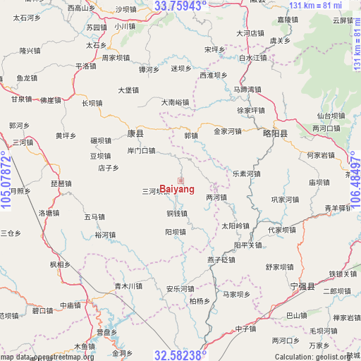
Baiyang GPS coordinates[2]
33° 10' 22.368" North, 105° 46' 54.624" East
| Map corner | latitude | longitude |
|---|---|---|
| Upper-left | 33.75943°, | 105.07872° |
| Center: | 33.17288°, | 105.78184° |
| Lower-right: | 32.58238°, | 106.48497° |
| Map W x H: | 130.9×130.9 km | = 81.3×81.3mi |
| max Lat: | 53.31946° ⇑33.1% North |
| Baiyang: | 33.17288° |
| min Lat: | ⇓66.9% South 18.22056° |
| min Long | Baiyang | max Long |
| 75.07348° | 105.78184° | 134.28917° |
| W 12.5%⇐ | ⇒87.5% E |
Elevation
Elevation of Baiyang is 1056 m = 3465 ft, and this is 571.2 m = 1874 ft above average elevation for this country.
| Max E: |
5622 m = 18445 ft | 13.8% |
| Baiyang | 1056 m 3465 ft | |
| Avg. | 484.8 m = 1591 ft | |
Min E: |
-3 m = -10 ft | 86.2% |
See also: China elevation on elevation.city.
Geographical zone
Baiyang is located in North temperate zone (between Tropic of Cancer and the Arctic Circle). Distance of this Northern Tropic circle is 1082.6 km =672.7 mi to South.| Distance of | km | miles | from Baiyang |
|---|---|---|---|
| North Pole | 6318.6 | 3926.2 | to North |
| Arctic Circle | 3712.7 | 2307 | to North |
| Tropic Cancer | 1082.6 | 672.7 | to South |
| Equator | 3688.5 | 2291.9 | to South |


Nearby cities:
15 places around Baiyang: (largest is in red/bold)
• Anmenkou
18.5 km =11.5 mi,  308°
308°
• Cangdu
20.1 km =12.5 mi,  116°
116°
• Guozhen
17.7 km =11 mi,  13°
13°
• Jia’an
11.3 km =7 mi,  330°
330°
• Jinjiahe
25.4 km =15.8 mi,  42°
42°
• Lesuhe
23.9 km =14.9 mi,  81°
81°
• Lianghe
14 km =8.7 mi,  113°
113°
• Sanheba
9.8 km =6.1 mi,  249°
249°
• Shijiayuan
24.5 km =15.2 mi,  57°
57°
• Taiyangling
25.6 km =15.9 mi,  126°
126°
• Tongqian
11.7 km =7.3 mi,  188°
188°
• Tuohe
19.1 km =11.9 mi,  157°
157°
• Yangba
18.1 km =11.2 mi,  184°
184°
• Yangtian
11 km =6.8 mi,  276°
276°
• Zuitai
24.1 km =15 mi,  316°
316°
Sources, notices
• [Note1] Compared only with cities in China existing in our database
• [Src1] Map data: © OpenStreetMap contributors (CC-BY-SA)
• [Src2] Other city data from geonames.org with taken over terms of usage.
• [Src3] Geographical zone / Annual Mean Temperature by Robert A. Rohde @ Wikipedia
