Zhangbaqiao geodata
Zhangbaqiao (Henan) is a seat of a fourth-order administrative division; located in China in Asia/Shanghai (GMT+8) time zone. In our database, there are 1268 cities with bigger population. Compared to other cities in China, 69.5% of cities are located further ↓South; 57.8% of cities are located further →East and 54.8% of cities have lower elevation than Zhangbaqiao. Note1


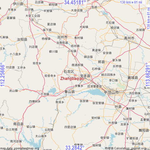
Zhangbaqiao GPS coordinates[2]
33° 52' 12" North, 112° 57' 35.208" East
| Map corner | latitude | longitude |
|---|---|---|
| Upper-left | 34.45181°, | 112.25666° |
| Center: | 33.87°, | 112.95978° |
| Lower-right: | 33.2842°, | 113.66291° |
| Map W x H: | 129.8×129.8 km | = 80.7×80.7mi |
| max Lat: | 53.31946° ⇑30.5% North |
| Zhangbaqiao: | 33.87° |
| min Lat: | ⇓69.5% South 18.22056° |
| min Long | Zhangbaqiao | max Long |
| 75.07348° | 112.95978° | 134.28917° |
| W 42.2%⇐ | ⇒57.8% E |
Elevation
Elevation of Zhangbaqiao is 204 m = 669 ft, and this is 280.8 m = 921 ft below average elevation for this country.
| Max E: |
5622 m = 18445 ft | 45.2% |
| Avg. | 484.8 m = 1591 ft | |
| Zhangbaqiao | 204 m = 669 ft | |
Min E: |
-3 m = -10 ft | 54.8% |
See also: China elevation on elevation.city.
Geographical zone
Zhangbaqiao is located in North temperate zone (between Tropic of Cancer and the Arctic Circle). Distance of this Northern Tropic circle is 1160.1 km =720.9 mi to South.| Distance of | km | miles | from Zhangbaqiao |
|---|---|---|---|
| North Pole | 6241.1 | 3878 | to North |
| Arctic Circle | 3635.2 | 2258.8 | to North |
| Tropic Cancer | 1160.1 | 720.9 | to South |
| Equator | 3766 | 2340.1 | to South |


Nearby cities:
15 places around Zhangbaqiao: (largest is in red/bold)
• Baofeng Chengguanzhen
9.7 km =6 mi,  89°
89°
• Cangtou
15.5 km =9.6 mi,  272°
272°
• Daying
10.3 km =6.4 mi,  316°
316°
• Dongzhou
17 km =10.6 mi,  235°
235°
• Liangwa
4.2 km =2.6 mi,  229°
229°
• Luyang
15.8 km =9.8 mi,  198°
198°
• Nanguzhuang
8.4 km =5.2 mi,  293°
293°
• Qianying
13.1 km =8.1 mi,  339°
339°
• Shangjiuwu
8.9 km =5.5 mi,  10°
10°
• Xiaoqi
10.6 km =6.6 mi,  61°
61°
• Xinji
9.7 km =6 mi,  157°
157°
• Yangzhuang
7.9 km =4.9 mi,  118°
118°
• Zhangdian
12.9 km =8 mi,  213°
213°
• Zhiyang
18.6 km =11.6 mi, 119°
• Zhouzhuang
14.5 km =9 mi, 94°
Sources, notices
• [Note1] Compared only with cities in China existing in our database
• [Src1] Map data: © OpenStreetMap contributors (CC-BY-SA)
• [Src2] Other city data from geonames.org with taken over terms of usage.
• [Src3] Geographical zone / Annual Mean Temperature by Robert A. Rohde @ Wikipedia
