Dongzhou geodata
Dongzhou (Henan) is a seat of a fourth-order administrative division; located in China in Asia/Shanghai (GMT+8) time zone. In our database, there are 1268 cities with bigger population. Compared to other cities in China, 69.2% of cities are located further ↓South; 58.7% of cities are located further →East and 50.1% of cities have lower elevation than Dongzhou. Note1


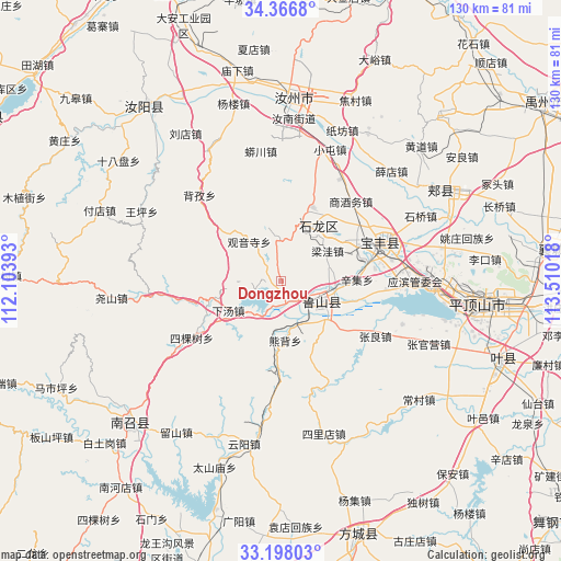
Dongzhou GPS coordinates[2]
33° 47' 3.876" North, 112° 48' 25.38" East
| Map corner | latitude | longitude |
|---|---|---|
| Upper-left | 34.3668°, | 112.10393° |
| Center: | 33.78441°, | 112.80705° |
| Lower-right: | 33.19803°, | 113.51018° |
| Map W x H: | 130×130 km | = 80.8×80.8mi |
| max Lat: | 53.31946° ⇑30.8% North |
| Dongzhou: | 33.78441° |
| min Lat: | ⇓69.2% South 18.22056° |
| min Long | Dongzhou | max Long |
| 75.07348° | 112.80705° | 134.28917° |
| W 41.3%⇐ | ⇒58.7% E |
Elevation
Elevation of Dongzhou is 166 m = 545 ft, and this is 318.8 m = 1046 ft below average elevation for this country.
| Max E: |
5622 m = 18445 ft | 49.9% |
| Avg. | 484.8 m = 1591 ft | |
| Dongzhou | 166 m = 545 ft | |
Min E: |
-3 m = -10 ft | 50.1% |
See also: China elevation on elevation.city.
Geographical zone
Dongzhou is located in North temperate zone (between Tropic of Cancer and the Arctic Circle). Distance of this Northern Tropic circle is 1150.6 km =714.9 mi to South.| Distance of | km | miles | from Dongzhou |
|---|---|---|---|
| North Pole | 6250.6 | 3883.9 | to North |
| Arctic Circle | 3644.7 | 2264.7 | to North |
| Tropic Cancer | 1150.6 | 714.9 | to South |
| Equator | 3756.5 | 2334.2 | to South |


Nearby cities:
15 places around Dongzhou: (largest is in red/bold)
• Cangtou
10.3 km =6.4 mi,  352°
352°
• Daying
18.4 km =11.4 mi,  22°
22°
• Guanyinsi
11.8 km =7.3 mi,  321°
321°
• Jizhong
20.3 km =12.6 mi,  215°
215°
• Liangwa
12.9 km =8 mi,  57°
57°
• Luyang
10.6 km =6.6 mi,  120°
120°
• Malou
20.2 km =12.6 mi,  125°
125°
• Nanguzhuang
14.4 km =8.9 mi,  26°
26°
• Ranghe
11 km =6.8 mi,  158°
158°
• Wawu
17.9 km =11.1 mi,  310°
310°
• Xiatang
13.8 km =8.6 mi,  238°
238°
• Xinji
17.9 km =11.1 mi,  88°
88°
• Xiongbei
13.6 km =8.5 mi,  178°
178°
• Zhangbaqiao
17 km =10.6 mi, 55°
• Zhangdian
7.2 km =4.5 mi,  100°
100°
Sources, notices
• [Note1] Compared only with cities in China existing in our database
• [Src1] Map data: © OpenStreetMap contributors (CC-BY-SA)
• [Src2] Other city data from geonames.org with taken over terms of usage.
• [Src3] Geographical zone / Annual Mean Temperature by Robert A. Rohde @ Wikipedia
