Chayuan geodata
Chayuan (Jiangxi) is a seat of a fourth-order administrative division; located in China in Asia/Shanghai (GMT+8) time zone. In our database, there are 1268 cities with bigger population. Compared to other cities in China, 80.5% of cities are located further ↑North; 55.2% of cities are located further ←West and 64.8% of cities have lower elevation than Chayuan. Note1


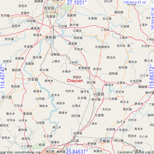
Chayuan GPS coordinates[2]
26° 28' 38.856" North, 115° 9' 38.124" East
| Map corner | latitude | longitude |
|---|---|---|
| Upper-left | 27.1051°, | 114.45747° |
| Center: | 26.47746°, | 115.16059° |
| Lower-right: | 25.84637°, | 115.86372° |
| Map W x H: | 140×140 km | = 87×87mi |
| max Lat: | 53.31946° ⇑80.5% North |
| Chayuan: | 26.47746° |
| min Lat: | ⇓19.5% South 18.22056° |
| min Long | Chayuan | max Long |
| 75.07348° | 115.16059° | 134.28917° |
| W 55.2%⇐ | ⇒44.8% E |
Elevation
Elevation of Chayuan is 321 m = 1053 ft, and this is 163.8 m = 537 ft below average elevation for this country.
| Max E: |
5622 m = 18445 ft | 35.2% |
| Avg. | 484.8 m = 1591 ft | |
| Chayuan | 321 m = 1053 ft | |
Min E: |
-3 m = -10 ft | 64.8% |
See also: China elevation on elevation.city.
Geographical zone
Chayuan is located in North temperate zone (between Tropic of Cancer and the Arctic Circle). Distance of this Northern Tropic circle is 338.1 km =210.1 mi to South.| Distance of | km | miles | from Chayuan |
|---|---|---|---|
| North Pole | 7063 | 4388.7 | to North |
| Arctic Circle | 4457.2 | 2769.6 | to North |
| Tropic Cancer | 338.1 | 210.1 | to South |
| Equator | 2944 | 1829.3 | to South |


Nearby cities:
15 places around Chayuan: (largest is in red/bold)
• Bailu
26.1 km =16.2 mi,  182°
182°
• Baoshan
21 km =13 mi,  226°
226°
• Butou
27.2 km =16.9 mi,  139°
139°
• Changgang
23.9 km =14.9 mi,  121°
121°
• Chongxian
19.9 km =12.4 mi,  66°
66°
• Fangtai
22.6 km =14 mi,  80°
80°
• Gaoxing
13.1 km =8.1 mi,  112°
112°
• Jiantian
26.6 km =16.5 mi,  212°
212°
• Laoyingpan
10.6 km =6.6 mi,  31°
31°
• Longping
15.5 km =9.6 mi,  151°
151°
• Shangyi
13.9 km =8.6 mi,  344°
344°
• Shuicha
10.7 km =6.6 mi,  298°
298°
• Xiaolong
24.6 km =15.3 mi,  22°
22°
• Yongfeng
19.7 km =12.2 mi,  165°
165°
• Zhonglong
25.6 km =15.9 mi,  1°
1°
Sources, notices
• [Note1] Compared only with cities in China existing in our database
• [Src1] Map data: © OpenStreetMap contributors (CC-BY-SA)
• [Src2] Other city data from geonames.org with taken over terms of usage.
• [Src3] Geographical zone / Annual Mean Temperature by Robert A. Rohde @ Wikipedia
