Butou geodata
Butou (Jiangxi) is a seat of a fourth-order administrative division; located in China in Asia/Shanghai (GMT+8) time zone. In our database, there are 1268 cities with bigger population. Compared to other cities in China, 81.2% of cities are located further ↑North; 56% of cities are located further ←West and 53.5% of cities have higher elevation than Butou. Note1


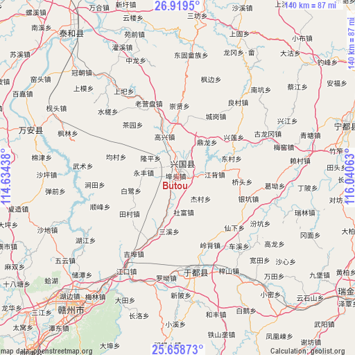
Butou GPS coordinates[2]
26° 17' 26.988" North, 115° 20' 15" East
| Map corner | latitude | longitude |
|---|---|---|
| Upper-left | 26.9195°, | 114.63438° |
| Center: | 26.29083°, | 115.3375° |
| Lower-right: | 25.65873°, | 116.04063° |
| Map W x H: | 140.2×140.2 km | = 87.1×87.1mi |
| max Lat: | 53.31946° ⇑81.2% North |
| Butou: | 26.29083° |
| min Lat: | ⇓18.8% South 18.22056° |
| min Long | Butou | max Long |
| 75.07348° | 115.3375° | 134.28917° |
| W 56%⇐ | ⇒44% E |
Elevation
Elevation of Butou is 140 m = 459 ft, and this is 344.8 m = 1131 ft below average elevation for this country.
| Max E: |
5622 m = 18445 ft | 53.5% |
| Avg. | 484.8 m = 1591 ft | |
| Butou | 140 m = 459 ft | |
Min E: |
-3 m = -10 ft | 46.5% |
See also: China elevation on elevation.city.
Geographical zone
Butou is located in North temperate zone (between Tropic of Cancer and the Arctic Circle). Distance of this Northern Tropic circle is 317.3 km =197.2 mi to South.| Distance of | km | miles | from Butou |
|---|---|---|---|
| North Pole | 7083.8 | 4401.7 | to North |
| Arctic Circle | 4477.9 | 2782.4 | to North |
| Tropic Cancer | 317.3 | 197.2 | to South |
| Equator | 2923.3 | 1816.5 | to South |


Nearby cities:
15 places around Butou: (largest is in red/bold)
• Bailu
19.7 km =12.2 mi,  254°
254°
• Changgang
8.8 km =5.5 mi,  18°
18°
• Chayuan
27.2 km =16.9 mi,  319°
319°
• Dinglong
18.1 km =11.2 mi,  40°
40°
• Dongcun
22.9 km =14.2 mi,  69°
69°
• Fangtai
24.9 km =15.5 mi,  10°
10°
• Gaoxing
16.7 km =10.4 mi,  340°
340°
• Jiangbei
14.5 km =9 mi,  85°
85°
• Jiecun
12.7 km =7.9 mi,  129°
129°
• Longkou
12.2 km =7.6 mi,  197°
197°
• Longping
12.5 km =7.8 mi,  305°
305°
• Ma’an
22.9 km =14.2 mi,  113°
113°
• Sanxixiang
21.5 km =13.4 mi,  190°
190°
• Shefu
14 km =8.7 mi,  168°
168°
• Yongfeng
12.9 km =8 mi,  277°
277°
Sources, notices
• [Note1] Compared only with cities in China existing in our database
• [Src1] Map data: © OpenStreetMap contributors (CC-BY-SA)
• [Src2] Other city data from geonames.org with taken over terms of usage.
• [Src3] Geographical zone / Annual Mean Temperature by Robert A. Rohde @ Wikipedia
