Danchang geodata
Danchang (Guangdong) is a seat of a fourth-order administrative division; located in China in Asia/Urumqi (GMT+6) time zone. In our database, there are 1268 cities with bigger population. Compared to other cities in China, 98.1% of cities are located further ↑North; 66.7% of cities are located further →East and 97.2% of cities have higher elevation than Danchang. Note1


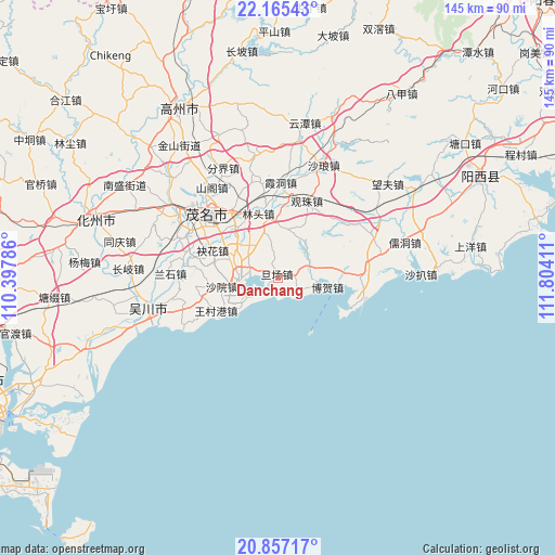
Danchang GPS coordinates[2]
21° 30' 45.972" North, 111° 6' 3.528" East
| Map corner | latitude | longitude |
|---|---|---|
| Upper-left | 22.16543°, | 110.39786° |
| Center: | 21.51277°, | 111.10098° |
| Lower-right: | 20.85717°, | 111.80411° |
| Map W x H: | 145.5×145.5 km | = 90.4×90.4mi |
| max Lat: | 53.31946° ⇑98.1% North |
| Danchang: | 21.51277° |
| min Lat: | ⇓1.9% South 18.22056° |
| min Long | Danchang | max Long |
| 75.07348° | 111.10098° | 134.28917° |
| W 33.3%⇐ | ⇒66.7% E |
Elevation
Elevation of Danchang is 5 m = 16 ft, and this is 479.8 m = 1574 ft below average elevation for this country.
| Max E: |
5622 m = 18445 ft | 97.2% |
| Avg. | 484.8 m = 1591 ft | |
| Danchang | 5 m = 16 ft | |
Min E: |
-3 m = -10 ft | 2.8% |
See also: China elevation on elevation.city.
Geographical zone
Danchang is located in North Torrid zone (between Equator and Tropic of Cancer). Distance of this Northern Tropic circle is 213.9 km =132.9 mi to North.| Distance of | km | miles | from Danchang |
|---|---|---|---|
| North Pole | 7615.1 | 4731.8 | to North |
| Arctic Circle | 5009.2 | 3112.6 | to North |
| Tropic Cancer | 213.9 | 132.9 | to North |
| Equator | 2392 | 1486.3 | to South |


Nearby cities:
15 places around Danchang: (largest is in red/bold)
• Bohe
12.5 km =7.8 mi,  101°
101°
• Diancheng
20.6 km =12.8 mi,  88°
88°
• Gaodi
12.1 km =7.5 mi,  262°
262°
• Guanzhu
21.1 km =13.1 mi,  20°
20°
• Lintou
17.8 km =11.1 mi,  342°
342°
• Magang
7.9 km =4.9 mi,  61°
61°
• Meihua
18.6 km =11.6 mi,  293°
293°
• Nanhai
8.9 km =5.5 mi,  239°
239°
• Poxin
17.5 km =10.9 mi,  325°
325°
• Qijing
12.7 km =7.9 mi,  299°
299°
• Shayuan
14.3 km =8.9 mi, 239°
• Shuidong
10.3 km =6.4 mi,  270°
270°
• Shuzi
13.1 km =8.1 mi,  74°
74°
• Wangcungang
19.1 km =11.9 mi, 241°
• Xiaoliang
21.9 km =13.6 mi, 264°
Sources, notices
• [Note1] Compared only with cities in China existing in our database
• [Src1] Map data: © OpenStreetMap contributors (CC-BY-SA)
• [Src2] Other city data from geonames.org with taken over terms of usage.
• [Src3] Geographical zone / Annual Mean Temperature by Robert A. Rohde @ Wikipedia
