Fulin geodata
Fulin (Guangdong) is a seat of a fourth-order administrative division; located in China in Asia/Shanghai (GMT+8) time zone. In our database, there are 1268 cities with bigger population. Compared to other cities in China, 95.8% of cities are located further ↑North; 63.1% of cities are located further →East and 52.6% of cities have higher elevation than Fulin. Note1


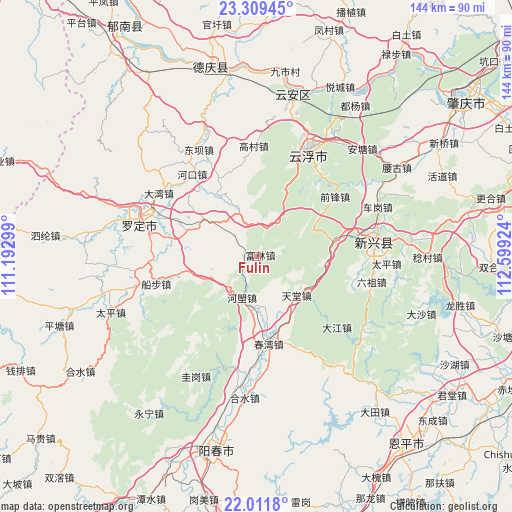
Fulin GPS coordinates[2]
22° 39' 43.776" North, 111° 53' 45.996" East
| Map corner | latitude | longitude |
|---|---|---|
| Upper-left | 23.30945°, | 111.19299° |
| Center: | 22.66216°, | 111.89611° |
| Lower-right: | 22.0118°, | 112.59924° |
| Map W x H: | 144.3×144.3 km | = 89.7×89.7mi |
| max Lat: | 53.31946° ⇑95.8% North |
| Fulin: | 22.66216° |
| min Lat: | ⇓4.2% South 18.22056° |
| min Long | Fulin | max Long |
| 75.07348° | 111.89611° | 134.28917° |
| W 36.9%⇐ | ⇒63.1% E |
Elevation
Elevation of Fulin is 146 m = 479 ft, and this is 338.8 m = 1112 ft below average elevation for this country.
| Max E: |
5622 m = 18445 ft | 52.6% |
| Avg. | 484.8 m = 1591 ft | |
| Fulin | 146 m = 479 ft | |
Min E: |
-3 m = -10 ft | 47.4% |
See also: China elevation on elevation.city.
Geographical zone
Fulin is located in North Torrid zone (between Equator and Tropic of Cancer). Distance of this Northern Tropic circle is 86.1 km =53.5 mi to North.| Distance of | km | miles | from Fulin |
|---|---|---|---|
| North Pole | 7487.3 | 4652.4 | to North |
| Arctic Circle | 4881.4 | 3033.2 | to North |
| Tropic Cancer | 86.1 | 53.5 | to North |
| Equator | 2519.8 | 1565.7 | to South |


Nearby cities:
15 places around Fulin: (largest is in red/bold)
• Baishi
20.5 km =12.7 mi,  329°
329°
• Bingtang
20 km =12.4 mi,  257°
257°
• Chuanbu
29.2 km =18.1 mi,  254°
254°
• Chunwan
25.1 km =15.6 mi,  171°
171°
• Helang
12.3 km =7.6 mi,  198°
198°
• Hetou
17.4 km =10.8 mi,  119°
119°
• Huashi
24.5 km =15.2 mi,  298°
298°
• Jinji
9.6 km =6 mi,  306°
306°
• Lezhu
22.7 km =14.1 mi,  80°
80°
• Nansheng
25.1 km =15.6 mi,  42°
42°
• Pingtang
18 km =11.2 mi, 305°
• Shiwang
15.4 km =9.6 mi, 167°
• Songbai
20.2 km =12.6 mi,  184°
184°
• Tiantang
15.4 km =9.6 mi,  136°
136°
• Weidi
24.2 km =15 mi,  283°
283°
Sources, notices
• [Note1] Compared only with cities in China existing in our database
• [Src1] Map data: © OpenStreetMap contributors (CC-BY-SA)
• [Src2] Other city data from geonames.org with taken over terms of usage.
• [Src3] Geographical zone / Annual Mean Temperature by Robert A. Rohde @ Wikipedia
