Yanghe geodata
Yanghe (Guangdong) is a seat of a fourth-order administrative division; located in China in Asia/Shanghai (GMT+8) time zone. In our database, there are 1268 cities with bigger population. Compared to other cities in China, 95.1% of cities are located further ↑North; 58.7% of cities are located further →East and 94.3% of cities have higher elevation than Yanghe. Note1


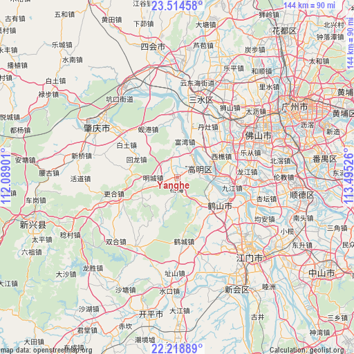
Yanghe GPS coordinates[2]
22° 52' 5.808" North, 112° 47' 31.668" East
| Map corner | latitude | longitude |
|---|---|---|
| Upper-left | 23.51458°, | 112.08901° |
| Center: | 22.86828°, | 112.79213° |
| Lower-right: | 22.21889°, | 113.49526° |
| Map W x H: | 144.1×144.1 km | = 89.5×89.5mi |
| max Lat: | 53.31946° ⇑95.1% North |
| Yanghe: | 22.86828° |
| min Lat: | ⇓4.9% South 18.22056° |
| min Long | Yanghe | max Long |
| 75.07348° | 112.79213° | 134.28917° |
| W 41.3%⇐ | ⇒58.7% E |
Elevation
Elevation of Yanghe is 7 m = 23 ft, and this is 477.8 m = 1568 ft below average elevation for this country.
| Max E: |
5622 m = 18445 ft | 94.3% |
| Avg. | 484.8 m = 1591 ft | |
| Yanghe | 7 m = 23 ft | |
Min E: |
-3 m = -10 ft | 5.7% |
See also: China elevation on elevation.city.
Geographical zone
Yanghe is located in North Torrid zone (between Equator and Tropic of Cancer). Distance of this Northern Tropic circle is 63.2 km =39.3 mi to North.| Distance of | km | miles | from Yanghe |
|---|---|---|---|
| North Pole | 7464.3 | 4638.1 | to North |
| Arctic Circle | 4858.5 | 3018.9 | to North |
| Tropic Cancer | 63.2 | 39.3 | to North |
| Equator | 2542.7 | 1580 | to South |


Nearby cities:
15 places around Yanghe: (largest is in red/bold)
• Baini
22 km =13.7 mi,  11°
11°
• Baitu
23.8 km =14.8 mi,  303°
303°
• Danzao
23 km =14.3 mi,  32°
32°
• Gulao
15 km =9.3 mi,  104°
104°
• Hecheng
10.3 km =6.4 mi,  67°
67°
• Huilong
18 km =11.2 mi,  291°
291°
• Jiaotang
21.4 km =13.3 mi,  282°
282°
• Jinli
23.4 km =14.5 mi,  356°
356°
• Jiujiang
22.3 km =13.9 mi, 99°
• Longkou
15.8 km =9.8 mi,  131°
131°
• Mingcheng
10.3 km =6.4 mi,  263°
263°
• Shaping
20.2 km =12.6 mi,  122°
122°
• Taoyuan
20.4 km =12.7 mi,  142°
142°
• Xiangang
23.4 km =14.5 mi,  326°
326°
• Xiqiao
19.9 km =12.4 mi,  64°
64°
Sources, notices
• [Note1] Compared only with cities in China existing in our database
• [Src1] Map data: © OpenStreetMap contributors (CC-BY-SA)
• [Src2] Other city data from geonames.org with taken over terms of usage.
• [Src3] Geographical zone / Annual Mean Temperature by Robert A. Rohde @ Wikipedia
