Hecheng geodata
Hecheng (Guangdong) is a seat of a fourth-order administrative division; located in China in Asia/Shanghai (GMT+8) time zone. In our database, there are 1268 cities with bigger population. Compared to other cities in China, 94.9% of cities are located further ↑North; 58.2% of cities are located further →East and 94.3% of cities have higher elevation than Hecheng. Note1


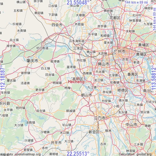
Hecheng GPS coordinates[2]
22° 54' 15.66" North, 112° 53' 5.964" East
| Map corner | latitude | longitude |
|---|---|---|
| Upper-left | 23.55048°, | 112.18187° |
| Center: | 22.90435°, | 112.88499° |
| Lower-right: | 22.25513°, | 113.58812° |
| Map W x H: | 144×144 km | = 89.5×89.5mi |
| max Lat: | 53.31946° ⇑94.9% North |
| Hecheng: | 22.90435° |
| min Lat: | ⇓5.1% South 18.22056° |
| min Long | Hecheng | max Long |
| 75.07348° | 112.88499° | 134.28917° |
| W 41.8%⇐ | ⇒58.2% E |
Elevation
Elevation of Hecheng is 7 m = 23 ft, and this is 477.8 m = 1568 ft below average elevation for this country.
| Max E: |
5622 m = 18445 ft | 94.3% |
| Avg. | 484.8 m = 1591 ft | |
| Hecheng | 7 m = 23 ft | |
Min E: |
-3 m = -10 ft | 5.7% |
See also: China elevation on elevation.city.
Geographical zone
Hecheng is located in North Torrid zone (between Equator and Tropic of Cancer). Distance of this Northern Tropic circle is 59.2 km =36.8 mi to North.| Distance of | km | miles | from Hecheng |
|---|---|---|---|
| North Pole | 7460.3 | 4635.6 | to North |
| Arctic Circle | 4854.4 | 3016.4 | to North |
| Tropic Cancer | 59.2 | 36.8 | to North |
| Equator | 2546.7 | 1582.4 | to South |


Nearby cities:
15 places around Hecheng: (largest is in red/bold)
• Baini
18.3 km =11.4 mi,  343°
343°
• Danzao
15.6 km =9.7 mi,  10°
10°
• Gulao
9.2 km =5.7 mi,  147°
147°
• Jinli
22.3 km =13.9 mi,  330°
330°
• Jiujiang
14.6 km =9.1 mi,  121°
121°
• Lecong
20.5 km =12.7 mi,  72°
72°
• Longjiang
18.9 km =11.7 mi,  96°
96°
• Longkou
14.6 km =9.1 mi,  171°
171°
• Mingcheng
20.4 km =12.7 mi,  255°
255°
• Nanzhuang
15.2 km =9.4 mi,  52°
52°
• Shaping
16.7 km =10.4 mi, 153°
• Shiwan
22.4 km =13.9 mi,  61°
61°
• Taoyuan
20.5 km =12.7 mi, 172°
• Xiqiao
9.6 km =6 mi, 61°
• Yanghe
10.3 km =6.4 mi,  247°
247°
Sources, notices
• [Note1] Compared only with cities in China existing in our database
• [Src1] Map data: © OpenStreetMap contributors (CC-BY-SA)
• [Src2] Other city data from geonames.org with taken over terms of usage.
• [Src3] Geographical zone / Annual Mean Temperature by Robert A. Rohde @ Wikipedia
