Gulu geodata
Gulu (Chongqing) is a seat of a fourth-order administrative division; located in China in Asia/Shanghai (GMT+8) time zone. In our database, there are 1268 cities with bigger population. Compared to other cities in China, 55.9% of cities are located further ↑North; 84.4% of cities are located further →East and 74.3% of cities have lower elevation than Gulu. Note1


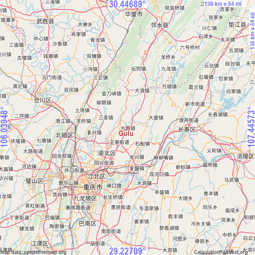
Gulu GPS coordinates[2]
29° 50' 19.86" North, 106° 44' 33.36" East
| Map corner | latitude | longitude |
|---|---|---|
| Upper-left | 30.44689°, | 106.03948° |
| Center: | 29.83885°, | 106.7426° |
| Lower-right: | 29.22709°, | 107.44573° |
| Map W x H: | 135.6×135.6 km | = 84.3×84.3mi |
| max Lat: | 53.31946° ⇑55.9% North |
| Gulu: | 29.83885° |
| min Lat: | ⇓44.1% South 18.22056° |
| min Long | Gulu | max Long |
| 75.07348° | 106.7426° | 134.28917° |
| W 15.6%⇐ | ⇒84.4% E |
Elevation
Elevation of Gulu is 507 m = 1663 ft, and this is 22.2 m = 73 ft above average elevation for this country.
| Max E: |
5622 m = 18445 ft | 25.7% |
| Gulu | 507 m 1663 ft | |
| Avg. | 484.8 m = 1591 ft | |
Min E: |
-3 m = -10 ft | 74.3% |
See also: China elevation on elevation.city.
Geographical zone
Gulu is located in North temperate zone (between Tropic of Cancer and the Arctic Circle). Distance of this Northern Tropic circle is 711.9 km =442.4 mi to South.| Distance of | km | miles | from Gulu |
|---|---|---|---|
| North Pole | 6689.3 | 4156.5 | to North |
| Arctic Circle | 4083.4 | 2537.3 | to North |
| Tropic Cancer | 711.9 | 442.4 | to South |
| Equator | 3317.8 | 2061.6 | to South |


Nearby cities:
15 places around Gulu: (largest is in red/bold)
• Cizhu
16.3 km =10.1 mi,  359°
359°
• Dasheng
16 km =9.9 mi,  69°
69°
• Dawan
21.4 km =13.3 mi,  20°
20°
• Fuxing
18 km =11.2 mi,  262°
262°
• Huixing
21.2 km =13.2 mi,  215°
215°
• Jindaoxia
20.5 km =12.7 mi,  334°
334°
• Jingguan
18.3 km =11.4 mi,  290°
290°
• Liuyin
18.7 km =11.6 mi,  316°
316°
• Longxing
15.9 km =9.9 mi,  162°
162°
• Mu’er
10.2 km =6.3 mi,  248°
248°
• Shichuan
11.2 km =7 mi,  136°
136°
• Shuangfengqiao
17.4 km =10.8 mi, 219°
• Tongjing
10.1 km =6.3 mi,  78°
78°
• Xinglong
6.6 km =4.1 mi, 327°
• Yufengshan
20.9 km =13 mi,  200°
200°
Sources, notices
• [Note1] Compared only with cities in China existing in our database
• [Src1] Map data: © OpenStreetMap contributors (CC-BY-SA)
• [Src2] Other city data from geonames.org with taken over terms of usage.
• [Src3] Geographical zone / Annual Mean Temperature by Robert A. Rohde @ Wikipedia
