Zhongshan geodata
Zhongshan (Guangdong) is a populated place; located in China in Asia/Urumqi (GMT+6) time zone. With population of 3,121,275 people, there are 35 cities with bigger population in this country. Compared to other cities in China, 98.3% of cities are located further ↑North; 68.8% of cities are located further →East and 86.2% of cities have higher elevation than Zhongshan. Note1


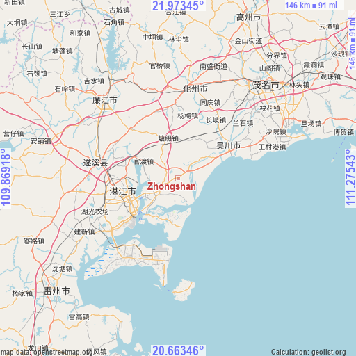
Zhongshan GPS coordinates[2]
21° 19' 11.712" North, 110° 34' 20.28" East
| Map corner | latitude | longitude |
|---|---|---|
| Upper-left | 21.97345°, | 109.86918° |
| Center: | 21.31992°, | 110.5723° |
| Lower-right: | 20.66346°, | 111.27543° |
| Map W x H: | 145.7×145.7 km | = 90.5×90.5mi |
| max Lat: | 53.31946° ⇑98.3% North |
| Zhongshan: | 21.31992° |
| min Lat: | ⇓1.7% South 18.22056° |
| min Long | Zhongshan | max Long |
| 75.07348° | 110.5723° | 134.28917° |
| W 31.2%⇐ | ⇒68.8% E |
Elevation
Elevation of Zhongshan is 14 m = 46 ft, and this is 470.8 m = 1545 ft below average elevation for this country.
| Max E: |
5622 m = 18445 ft | 86.2% |
| Avg. | 484.8 m = 1591 ft | |
| Zhongshan | 14 m = 46 ft | |
Min E: |
-3 m = -10 ft | 13.8% |
See also: Zhongshan elevation on elevation.city.
Geographical zone
Zhongshan is located in North Torrid zone (between Equator and Tropic of Cancer). Distance of this Northern Tropic circle is 235.4 km =146.3 mi to North.| Distance of | km | miles | from Zhongshan |
|---|---|---|---|
| North Pole | 7636.5 | 4745.1 | to North |
| Arctic Circle | 5030.6 | 3125.9 | to North |
| Tropic Cancer | 235.4 | 146.3 | to North |
| Equator | 2370.6 | 1473 | to South |


Nearby cities:
15 places around Zhongshan: (largest is in red/bold)
• Chikan
22.7 km =14.1 mi,  256°
256°
• Gongnong
23.2 km =14.4 mi,  232°
232°
• Guandu
15.7 km =9.8 mi,  297°
297°
• Huangpo
1.7 km =1.1 mi,  101°
101°
• Longtou
7 km =4.3 mi,  308°
308°
• Nandiao
15.1 km =9.4 mi,  239°
239°
• Nanqiao
22.8 km =14.2 mi, 255°
• Nansan
18.8 km =11.7 mi,  186°
186°
• Potou
15.3 km =9.5 mi,  248°
248°
• Qiantang
10.6 km =6.6 mi,  157°
157°
• Tangtuzhui
17.5 km =10.9 mi,  348°
348°
• Tangwei
18.2 km =11.3 mi,  62°
62°
• Wuyang
12.4 km =7.7 mi,  75°
75°
• Zhangpu
19.4 km =12.1 mi,  41°
41°
• Zhenwen
15.1 km =9.4 mi,  50°
50°
Sources, notices
• [Note1] Compared only with cities in China existing in our database
• [Src1] Map data: © OpenStreetMap contributors (CC-BY-SA)
• [Src2] Other city data from geonames.org with taken over terms of usage.
• [Src3] Geographical zone / Annual Mean Temperature by Robert A. Rohde @ Wikipedia
