Nandiao geodata
Nandiao (Guangdong) is a seat of a fourth-order administrative division; located in China in Asia/Urumqi (GMT+6) time zone. In our database, there are 1268 cities with bigger population. Compared to other cities in China, 98.3% of cities are located further ↑North; 69.3% of cities are located further →East and 99.4% of cities have higher elevation than Nandiao. Note1


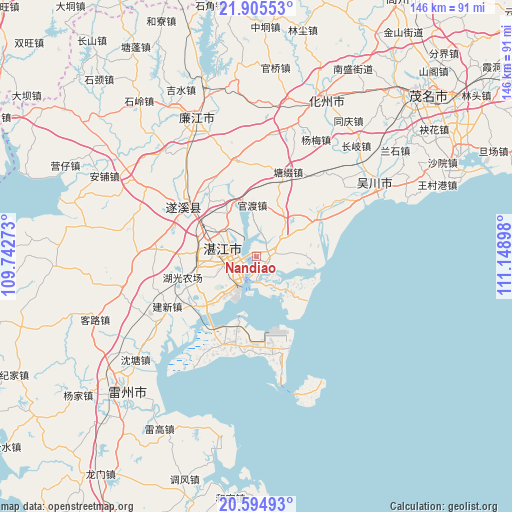
Nandiao GPS coordinates[2]
21° 15' 6.084" North, 110° 26' 45.06" East
| Map corner | latitude | longitude |
|---|---|---|
| Upper-left | 21.90553°, | 109.74273° |
| Center: | 21.25169°, | 110.44585° |
| Lower-right: | 20.59493°, | 111.14898° |
| Map W x H: | 145.7×145.7 km | = 90.5×90.5mi |
| max Lat: | 53.31946° ⇑98.3% North |
| Nandiao: | 21.25169° |
| min Lat: | ⇓1.7% South 18.22056° |
| min Long | Nandiao | max Long |
| 75.07348° | 110.44585° | 134.28917° |
| W 30.7%⇐ | ⇒69.3% E |
Elevation
Elevation of Nandiao is 2 m = 7 ft, and this is 482.8 m = 1584 ft below average elevation for this country.
| Max E: |
5622 m = 18445 ft | 99.4% |
| Avg. | 484.8 m = 1591 ft | |
| Nandiao | 2 m = 7 ft | |
Min E: |
-3 m = -10 ft | 0.6% |
See also: China elevation on elevation.city.
Geographical zone
Nandiao is located in North Torrid zone (between Equator and Tropic of Cancer). Distance of this Northern Tropic circle is 243 km =151 mi to North.| Distance of | km | miles | from Nandiao |
|---|---|---|---|
| North Pole | 7644.1 | 4749.8 | to North |
| Arctic Circle | 5038.2 | 3130.6 | to North |
| Tropic Cancer | 243 | 151 | to North |
| Equator | 2363 | 1468.3 | to South |


Nearby cities:
15 places around Nandiao: (largest is in red/bold)
• Chikan
9.3 km =5.8 mi,  283°
283°
• Dongjian
24.5 km =15.2 mi,  167°
167°
• Gongnong
8.4 km =5.2 mi,  219°
219°
• Guandu
14.8 km =9.2 mi,  356°
356°
• Haitou
8.3 km =5.2 mi,  227°
227°
• Huangpo
16.4 km =10.2 mi,  63°
63°
• Huguang
21.5 km =13.4 mi, 229°
• Longtou
14.2 km =8.8 mi,  32°
32°
• Mazhang
13.1 km =8.1 mi, 281°
• Nanqiao
9.2 km =5.7 mi, 281°
• Nansan
15.5 km =9.6 mi,  135°
135°
• Potou
2.1 km =1.3 mi,  329°
329°
• Qiantang
17.4 km =10.8 mi,  97°
97°
• Zhanjiang
11.2 km =7 mi,  287°
287°
• Zhongshan
15.1 km =9.4 mi, 59°
Sources, notices
• [Note1] Compared only with cities in China existing in our database
• [Src1] Map data: © OpenStreetMap contributors (CC-BY-SA)
• [Src2] Other city data from geonames.org with taken over terms of usage.
• [Src3] Geographical zone / Annual Mean Temperature by Robert A. Rohde @ Wikipedia
