Guandu geodata
Guandu (Guangdong) is a seat of a fourth-order administrative division; located in China in Asia/Urumqi (GMT+6) time zone. In our database, there are 1268 cities with bigger population. Compared to other cities in China, 98.2% of cities are located further ↑North; 69.3% of cities are located further →East and 83.4% of cities have higher elevation than Guandu. Note1


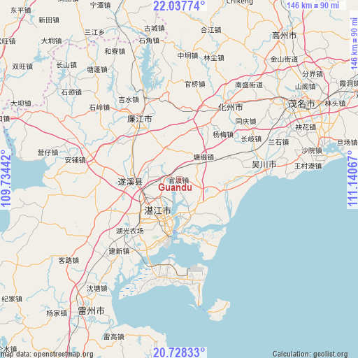
Guandu GPS coordinates[2]
21° 23' 4.2" North, 110° 26' 15.144" East
| Map corner | latitude | longitude |
|---|---|---|
| Upper-left | 22.03774°, | 109.73442° |
| Center: | 21.3845°, | 110.43754° |
| Lower-right: | 20.72833°, | 111.14067° |
| Map W x H: | 145.6×145.6 km | = 90.5×90.5mi |
| max Lat: | 53.31946° ⇑98.2% North |
| Guandu: | 21.3845° |
| min Lat: | ⇓1.8% South 18.22056° |
| min Long | Guandu | max Long |
| 75.07348° | 110.43754° | 134.28917° |
| W 30.7%⇐ | ⇒69.3% E |
Elevation
Elevation of Guandu is 19 m = 62 ft, and this is 465.8 m = 1528 ft below average elevation for this country.
| Max E: |
5622 m = 18445 ft | 83.4% |
| Avg. | 484.8 m = 1591 ft | |
| Guandu | 19 m = 62 ft | |
Min E: |
-3 m = -10 ft | 16.6% |
See also: China elevation on elevation.city.
Geographical zone
Guandu is located in North Torrid zone (between Equator and Tropic of Cancer). Distance of this Northern Tropic circle is 228.2 km =141.8 mi to North.| Distance of | km | miles | from Guandu |
|---|---|---|---|
| North Pole | 7629.3 | 4740.6 | to North |
| Arctic Circle | 5023.4 | 3121.4 | to North |
| Tropic Cancer | 228.2 | 141.8 | to North |
| Equator | 2377.7 | 1477.4 | to South |


Nearby cities:
15 places around Guandu: (largest is in red/bold)
• Chikan
15 km =9.3 mi,  212°
212°
• Daqiao
21.9 km =13.6 mi,  16°
16°
• Gongnong
21.8 km =13.5 mi,  191°
191°
• Haitou
21 km =13 mi, 194°
• Huangpo
17.3 km =10.7 mi,  115°
115°
• Liangdong
13.5 km =8.4 mi,  341°
341°
• Longtou
8.9 km =5.5 mi,  108°
108°
• Mazhang
17 km =10.6 mi,  224°
224°
• Nandiao
14.8 km =9.2 mi,  176°
176°
• Nanqiao
15.3 km =9.5 mi, 212°
• Potou
12.9 km =8 mi, 180°
• Suicheng
19.4 km =12.1 mi,  268°
268°
• Tangtuzhui
14.4 km =8.9 mi,  46°
46°
• Zhanjiang
15.1 km =9.4 mi, 220°
• Zhongshan
15.7 km =9.8 mi, 117°
Sources, notices
• [Note1] Compared only with cities in China existing in our database
• [Src1] Map data: © OpenStreetMap contributors (CC-BY-SA)
• [Src2] Other city data from geonames.org with taken over terms of usage.
• [Src3] Geographical zone / Annual Mean Temperature by Robert A. Rohde @ Wikipedia
