Bopu geodata
Bopu (Guangdong) is a seat of a fourth-order administrative division; located in China in Asia/Urumqi (GMT+6) time zone. In our database, there are 1268 cities with bigger population. Compared to other cities in China, 98.2% of cities are located further ↑North; 67.9% of cities are located further →East and 88.7% of cities have higher elevation than Bopu. Note1


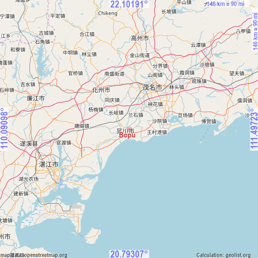
Bopu GPS coordinates[2]
21° 26' 56.256" North, 110° 47' 38.76" East
| Map corner | latitude | longitude |
|---|---|---|
| Upper-left | 22.10191°, | 110.09098° |
| Center: | 21.44896°, | 110.7941° |
| Lower-right: | 20.79307°, | 111.49723° |
| Map W x H: | 145.5×145.5 km | = 90.4×90.4mi |
| max Lat: | 53.31946° ⇑98.2% North |
| Bopu: | 21.44896° |
| min Lat: | ⇓1.8% South 18.22056° |
| min Long | Bopu | max Long |
| 75.07348° | 110.7941° | 134.28917° |
| W 32.1%⇐ | ⇒67.9% E |
Elevation
Elevation of Bopu is 11 m = 36 ft, and this is 473.8 m = 1554 ft below average elevation for this country.
| Max E: |
5622 m = 18445 ft | 88.7% |
| Avg. | 484.8 m = 1591 ft | |
| Bopu | 11 m = 36 ft | |
Min E: |
-3 m = -10 ft | 11.3% |
See also: China elevation on elevation.city.
Geographical zone
Bopu is located in North Torrid zone (between Equator and Tropic of Cancer). Distance of this Northern Tropic circle is 221 km =137.3 mi to North.| Distance of | km | miles | from Bopu |
|---|---|---|---|
| North Pole | 7622.2 | 4736.2 | to North |
| Arctic Circle | 5016.3 | 3117 | to North |
| Tropic Cancer | 221 | 137.3 | to North |
| Equator | 2384.9 | 1481.9 | to South |


Nearby cities:
15 places around Bopu: (largest is in red/bold)
• Aotou
13.3 km =8.3 mi,  29°
29°
• Changqi
11.9 km =7.4 mi,  322°
322°
• Dashanjiang
2.3 km =1.4 mi,  172°
172°
• Haibin
5.7 km =3.5 mi,  191°
191°
• Lanshi
8.2 km =5.1 mi,  24°
24°
• Meilu
2.5 km =1.6 mi,  229°
229°
• Qianshui
15.8 km =9.8 mi,  344°
344°
• Tanba
6.3 km =3.9 mi,  93°
93°
• Tangwei
9 km =5.6 mi, 228°
• Wangcungang
15.2 km =9.4 mi,  98°
98°
• Wuchuan
3.1 km =1.9 mi,  287°
287°
• Wuyang
15.7 km =9.8 mi,  224°
224°
• Xiaoliang
11.1 km =6.9 mi,  63°
63°
• Zhangpu
10.2 km =6.3 mi,  271°
271°
• Zhenwen
12.3 km =7.6 mi,  247°
247°
Sources, notices
• [Note1] Compared only with cities in China existing in our database
• [Src1] Map data: © OpenStreetMap contributors (CC-BY-SA)
• [Src2] Other city data from geonames.org with taken over terms of usage.
• [Src3] Geographical zone / Annual Mean Temperature by Robert A. Rohde @ Wikipedia
