Feikeng geodata
Feikeng (Zhejiang) is a seat of a fourth-order administrative division; located in China in Asia/Shanghai (GMT+8) time zone. In our database, there are 1268 cities with bigger population. Compared to other cities in China, 62.1% of cities are located further ↑North; 88.8% of cities are located further ←West and 76.3% of cities have lower elevation than Feikeng. Note1


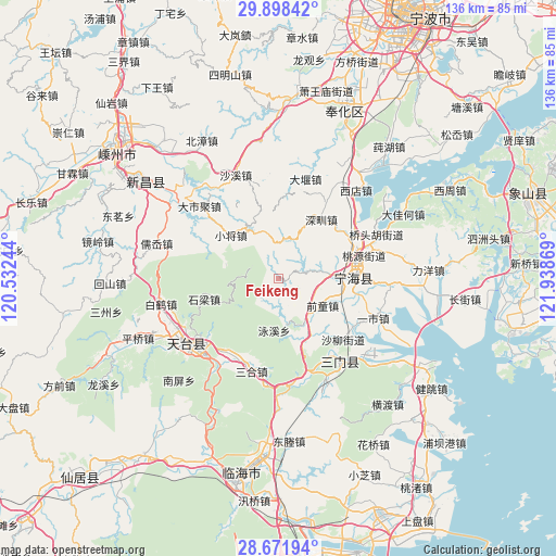
Feikeng GPS coordinates[2]
29° 17' 13.272" North, 121° 14' 8.016" East
| Map corner | latitude | longitude |
|---|---|---|
| Upper-left | 29.89842°, | 120.53244° |
| Center: | 29.28702°, | 121.23556° |
| Lower-right: | 28.67194°, | 121.93869° |
| Map W x H: | 136.4×136.4 km | = 84.8×84.8mi |
| max Lat: | 53.31946° ⇑62.1% North |
| Feikeng: | 29.28702° |
| min Lat: | ⇓37.9% South 18.22056° |
| min Long | Feikeng | max Long |
| 75.07348° | 121.23556° | 134.28917° |
| W 88.8%⇐ | ⇒11.2% E |
Elevation
Elevation of Feikeng is 554 m = 1818 ft, and this is 69.2 m = 227 ft above average elevation for this country.
| Max E: |
5622 m = 18445 ft | 23.7% |
| Feikeng | 554 m 1818 ft | |
| Avg. | 484.8 m = 1591 ft | |
Min E: |
-3 m = -10 ft | 76.3% |
See also: China elevation on elevation.city.
Geographical zone
Feikeng is located in North temperate zone (between Tropic of Cancer and the Arctic Circle). Distance of this Northern Tropic circle is 650.5 km =404.2 mi to South.| Distance of | km | miles | from Feikeng |
|---|---|---|---|
| North Pole | 6750.7 | 4194.7 | to North |
| Arctic Circle | 4144.8 | 2575.5 | to North |
| Tropic Cancer | 650.5 | 404.2 | to South |
| Equator | 3256.4 | 2023.4 | to South |


Nearby cities:
15 places around Feikeng: (largest is in red/bold)
• Chalu
12.1 km =7.5 mi,  140°
140°
• Chengguan
19 km =11.8 mi,  89°
89°
• Haiyou
22.6 km =14 mi, 143°
• Huangtan
11.9 km =7.4 mi, 85°
• Huangwu
23.5 km =14.6 mi,  196°
196°
• Ninghai
18.3 km =11.4 mi, 89°
• Qiantong
13.3 km =8.3 mi,  121°
121°
• Sangzhou
16.4 km =10.2 mi,  151°
151°
• Shaliu
22.1 km =13.7 mi,  133°
133°
• Shenzhen
17.5 km =10.9 mi,  35°
35°
• Shiliang
19.3 km =12 mi,  254°
254°
• Tantou
22.6 km =14 mi,  210°
210°
• Xiaojiang
15.8 km =9.8 mi,  312°
312°
• Yishi
25.2 km =15.7 mi,  112°
112°
• Zhu’ao
24.7 km =15.3 mi,  168°
168°
Sources, notices
• [Note1] Compared only with cities in China existing in our database
• [Src1] Map data: © OpenStreetMap contributors (CC-BY-SA)
• [Src2] Other city data from geonames.org with taken over terms of usage.
• [Src3] Geographical zone / Annual Mean Temperature by Robert A. Rohde @ Wikipedia
