Shiliang geodata
Shiliang (Zhejiang) is a seat of a fourth-order administrative division; located in China in Asia/Shanghai (GMT+8) time zone. In our database, there are 1268 cities with bigger population. Compared to other cities in China, 62.8% of cities are located further ↑North; 87.9% of cities are located further ←West and 81.3% of cities have lower elevation than Shiliang. Note1


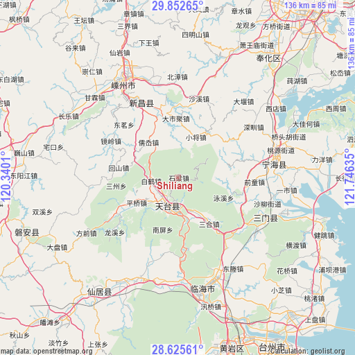
Shiliang GPS coordinates[2]
29° 14' 27.492" North, 121° 2' 35.592" East
| Map corner | latitude | longitude |
|---|---|---|
| Upper-left | 29.85265°, | 120.3401° |
| Center: | 29.24097°, | 121.04322° |
| Lower-right: | 28.62561°, | 121.74635° |
| Map W x H: | 136.4×136.4 km | = 84.8×84.8mi |
| max Lat: | 53.31946° ⇑62.8% North |
| Shiliang: | 29.24097° |
| min Lat: | ⇓37.2% South 18.22056° |
| min Long | Shiliang | max Long |
| 75.07348° | 121.04322° | 134.28917° |
| W 87.9%⇐ | ⇒12.1% E |
Elevation
Elevation of Shiliang is 758 m = 2487 ft, and this is 273.2 m = 896 ft above average elevation for this country.
| Max E: |
5622 m = 18445 ft | 18.7% |
| Shiliang | 758 m 2487 ft | |
| Avg. | 484.8 m = 1591 ft | |
Min E: |
-3 m = -10 ft | 81.3% |
See also: China elevation on elevation.city.
Geographical zone
Shiliang is located in North temperate zone (between Tropic of Cancer and the Arctic Circle). Distance of this Northern Tropic circle is 645.4 km =401 mi to South.| Distance of | km | miles | from Shiliang |
|---|---|---|---|
| North Pole | 6755.8 | 4197.9 | to North |
| Arctic Circle | 4149.9 | 2578.6 | to North |
| Tropic Cancer | 645.4 | 401 | to South |
| Equator | 3251.3 | 2020.3 | to South |


Nearby cities:
15 places around Shiliang: (largest is in red/bold)
• Baihedian
10.5 km =6.5 mi,  266°
266°
• Chalu
26.7 km =16.6 mi,  99°
99°
• Dacun
25.5 km =15.8 mi,  143°
143°
• Dashiju
22.7 km =14.1 mi,  357°
357°
• Dianqian
27.7 km =17.2 mi,  293°
293°
• Feikeng
19.3 km =12 mi,  74°
74°
• Hetou
27.7 km =17.2 mi,  169°
169°
• Huangwu
21.1 km =13.1 mi,  145°
145°
• Jietou
27.1 km =16.8 mi,  239°
239°
• Pingqiao
18.6 km =11.6 mi, 238°
• Ru’ao
18 km =11.2 mi,  317°
317°
• Tantou
16.1 km =10 mi, 152°
• Tiantai Chengguanzhen
11.7 km =7.3 mi,  186°
186°
• Xiaojiang
17.3 km =10.7 mi,  23°
23°
• Xinshichang
23.3 km =14.5 mi,  280°
280°
Sources, notices
• [Note1] Compared only with cities in China existing in our database
• [Src1] Map data: © OpenStreetMap contributors (CC-BY-SA)
• [Src2] Other city data from geonames.org with taken over terms of usage.
• [Src3] Geographical zone / Annual Mean Temperature by Robert A. Rohde @ Wikipedia
