Huyuan geodata
Huyuan (Zhejiang) is a seat of a fourth-order administrative division; located in China in Asia/Shanghai (GMT+8) time zone. In our database, there are 1268 cities with bigger population. Compared to other cities in China, 56.2% of cities are located further ↑North; 81.5% of cities are located further ←West and 64.9% of cities have higher elevation than Huyuan. Note1


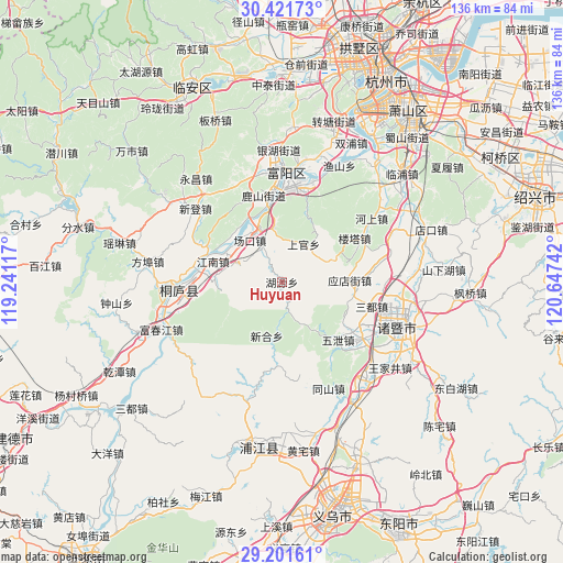
Huyuan GPS coordinates[2]
29° 48' 48.708" North, 119° 56' 39.444" East
| Map corner | latitude | longitude |
|---|---|---|
| Upper-left | 30.42173°, | 119.24117° |
| Center: | 29.81353°, | 119.94429° |
| Lower-right: | 29.20161°, | 120.64742° |
| Map W x H: | 135.7×135.7 km | = 84.3×84.3mi |
| max Lat: | 53.31946° ⇑56.2% North |
| Huyuan: | 29.81353° |
| min Lat: | ⇓43.8% South 18.22056° |
| min Long | Huyuan | max Long |
| 75.07348° | 119.94429° | 134.28917° |
| W 81.5%⇐ | ⇒18.5% E |
Elevation
Elevation of Huyuan is 73 m = 240 ft, and this is 411.8 m = 1351 ft below average elevation for this country.
| Max E: |
5622 m = 18445 ft | 64.9% |
| Avg. | 484.8 m = 1591 ft | |
| Huyuan | 73 m = 240 ft | |
Min E: |
-3 m = -10 ft | 35.1% |
See also: China elevation on elevation.city.
Geographical zone
Huyuan is located in North temperate zone (between Tropic of Cancer and the Arctic Circle). Distance of this Northern Tropic circle is 709 km =440.6 mi to South.| Distance of | km | miles | from Huyuan |
|---|---|---|---|
| North Pole | 6692.1 | 4158.3 | to North |
| Arctic Circle | 4086.2 | 2539 | to North |
| Tropic Cancer | 709 | 440.6 | to South |
| Equator | 3315 | 2059.8 | to South |


Nearby cities:
15 places around Huyuan: (largest is in red/bold)
• Changkou
12.8 km =8 mi,  329°
329°
• Dayuan
22 km =13.7 mi,  12°
12°
• Fengchuan
16.4 km =10.2 mi,  268°
268°
• Huanshan
13.2 km =8.2 mi,  351°
351°
• Longmen
10 km =6.2 mi,  1°
1°
• Louta
20.2 km =12.6 mi,  59°
59°
• Lushan
22.1 km =13.7 mi, 349°
• Shen’ao
11.5 km =7.1 mi,  292°
292°
• Shifu
15.9 km =9.9 mi,  281°
281°
• Shixiang
19.5 km =12.1 mi,  135°
135°
• Tanxi
20.6 km =12.8 mi,  180°
180°
• Xinhe
13.5 km =8.4 mi,  195°
195°
• Xintong
16.2 km =10.1 mi,  309°
309°
• Yingdianjie
16.4 km =10.2 mi,  88°
88°
• Zhaixi
18.6 km =11.6 mi, 289°
Sources, notices
• [Note1] Compared only with cities in China existing in our database
• [Src1] Map data: © OpenStreetMap contributors (CC-BY-SA)
• [Src2] Other city data from geonames.org with taken over terms of usage.
• [Src3] Geographical zone / Annual Mean Temperature by Robert A. Rohde @ Wikipedia
