Shen’ao geodata
Shen’ao (Zhejiang) is a seat of a fourth-order administrative division; located in China in Asia/Shanghai (GMT+8) time zone. In our database, there are 1268 cities with bigger population. Compared to other cities in China, 55.7% of cities are located further ↑North; 80.8% of cities are located further ←West and 65.8% of cities have higher elevation than Shen’ao. Note1


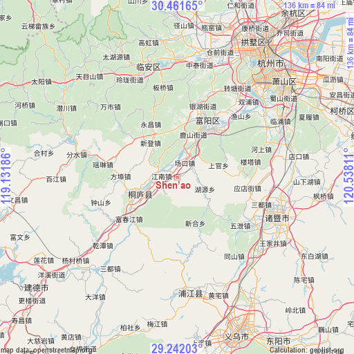
Shen’ao GPS coordinates[2]
29° 51' 13.32" North, 119° 50' 5.928" East
| Map corner | latitude | longitude |
|---|---|---|
| Upper-left | 30.46165°, | 119.13186° |
| Center: | 29.8537°, | 119.83498° |
| Lower-right: | 29.24203°, | 120.53811° |
| Map W x H: | 135.6×135.6 km | = 84.3×84.3mi |
| max Lat: | 53.31946° ⇑55.7% North |
| Shen’ao: | 29.8537° |
| min Lat: | ⇓44.3% South 18.22056° |
| min Long | Shen’ao | max Long |
| 75.07348° | 119.83498° | 134.28917° |
| W 80.8%⇐ | ⇒19.2% E |
Elevation
Elevation of Shen’ao is 69 m = 226 ft, and this is 415.8 m = 1364 ft below average elevation for this country.
| Max E: |
5622 m = 18445 ft | 65.8% |
| Avg. | 484.8 m = 1591 ft | |
| Shen’ao | 69 m = 226 ft | |
Min E: |
-3 m = -10 ft | 34.2% |
See also: China elevation on elevation.city.
Geographical zone
Shen’ao is located in North temperate zone (between Tropic of Cancer and the Arctic Circle). Distance of this Northern Tropic circle is 713.5 km =443.3 mi to South.| Distance of | km | miles | from Shen’ao |
|---|---|---|---|
| North Pole | 6687.6 | 4155.5 | to North |
| Arctic Circle | 4081.8 | 2536.3 | to North |
| Tropic Cancer | 713.5 | 443.3 | to South |
| Equator | 3319.4 | 2062.6 | to South |


Nearby cities:
15 places around Shen’ao: (largest is in red/bold)
• Changkou
7.8 km =4.8 mi,  31°
31°
• Fangbu
21.7 km =13.5 mi,  271°
271°
• Fengchuan
7.5 km =4.7 mi,  230°
230°
• Huanshan
12.2 km =7.6 mi,  44°
44°
• Huyuan
11.5 km =7.1 mi,  112°
112°
• Jiuxian
21.1 km =13.1 mi,  254°
254°
• Longmen
12.1 km =7.5 mi,  63°
63°
• Lushan
18.5 km =11.5 mi,  21°
21°
• Shifu
5.1 km =3.2 mi,  256°
256°
• Xindeng
16.6 km =10.3 mi,  321°
321°
• Xinhe
18.8 km =11.7 mi,  158°
158°
• Xintong
6.2 km =3.9 mi,  341°
341°
• Xukou
21.7 km =13.5 mi,  311°
311°
• Yongchang
22.8 km =14.2 mi,  334°
334°
• Zhaixi
7.2 km =4.5 mi,  284°
284°
Sources, notices
• [Note1] Compared only with cities in China existing in our database
• [Src1] Map data: © OpenStreetMap contributors (CC-BY-SA)
• [Src2] Other city data from geonames.org with taken over terms of usage.
• [Src3] Geographical zone / Annual Mean Temperature by Robert A. Rohde @ Wikipedia
