Langchuan geodata
Langchuan (Zhejiang) is a seat of a fourth-order administrative division; located in China in Asia/Shanghai (GMT+8) time zone. In our database, there are 1268 cities with bigger population. Compared to other cities in China, 59.8% of cities are located further ↑North; 73.8% of cities are located further ←West and 55.5% of cities have higher elevation than Langchuan. Note1


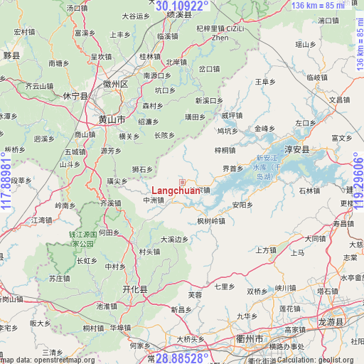
Langchuan GPS coordinates[2]
29° 29' 56.76" North, 118° 35' 34.548" East
| Map corner | latitude | longitude |
|---|---|---|
| Upper-left | 30.10922°, | 117.88981° |
| Center: | 29.4991°, | 118.59293° |
| Lower-right: | 28.88528°, | 119.29606° |
| Map W x H: | 136.1×136.1 km | = 84.6×84.6mi |
| max Lat: | 53.31946° ⇑59.8% North |
| Langchuan: | 29.4991° |
| min Lat: | ⇓40.2% South 18.22056° |
| min Long | Langchuan | max Long |
| 75.07348° | 118.59293° | 134.28917° |
| W 73.8%⇐ | ⇒26.2% E |
Elevation
Elevation of Langchuan is 128 m = 420 ft, and this is 356.8 m = 1171 ft below average elevation for this country.
| Max E: |
5622 m = 18445 ft | 55.5% |
| Avg. | 484.8 m = 1591 ft | |
| Langchuan | 128 m = 420 ft | |
Min E: |
-3 m = -10 ft | 44.5% |
See also: China elevation on elevation.city.
Geographical zone
Langchuan is located in North temperate zone (between Tropic of Cancer and the Arctic Circle). Distance of this Northern Tropic circle is 674.1 km =418.9 mi to South.| Distance of | km | miles | from Langchuan |
|---|---|---|---|
| North Pole | 6727.1 | 4180 | to North |
| Arctic Circle | 4121.2 | 2560.8 | to North |
| Tropic Cancer | 674.1 | 418.9 | to South |
| Equator | 3280 | 2038.1 | to South |


Nearby cities:
15 places around Langchuan: (largest is in red/bold)
• Anyang
24.5 km =15.2 mi,  111°
111°
• Changgai
18.9 km =11.7 mi,  339°
339°
• Dongshan
22.4 km =13.9 mi,  192°
192°
• Dujing
19.4 km =12.1 mi,  54°
54°
• Fengshuling
18.2 km =11.3 mi,  143°
143°
• Guocun
7.5 km =4.7 mi,  30°
30°
• Huangwei
21.6 km =13.4 mi,  12°
12°
• Jiangjia
6.9 km =4.3 mi, 111°
• Longyuan
10.8 km =6.7 mi,  183°
183°
• Shimen
21.3 km =13.2 mi,  313°
313°
• Tangwu
20.2 km =12.6 mi,  212°
212°
• Yangqitan
8.5 km =5.3 mi, 213°
• Yaojia
19.4 km =12.1 mi,  72°
72°
• Yujia
12.3 km =7.6 mi,  250°
250°
• Zhongzhou
12.3 km =7.6 mi,  238°
238°
Sources, notices
• [Note1] Compared only with cities in China existing in our database
• [Src1] Map data: © OpenStreetMap contributors (CC-BY-SA)
• [Src2] Other city data from geonames.org with taken over terms of usage.
• [Src3] Geographical zone / Annual Mean Temperature by Robert A. Rohde @ Wikipedia
