Yaojia geodata
Yaojia (Zhejiang) is a seat of a fourth-order administrative division; located in China in Asia/Shanghai (GMT+8) time zone. In our database, there are 1268 cities with bigger population. Compared to other cities in China, 59.2% of cities are located further ↑North; 74.9% of cities are located further ←West and 57.2% of cities have higher elevation than Yaojia. Note1


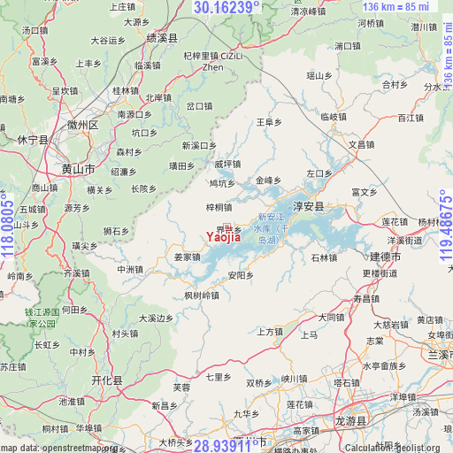
Yaojia GPS coordinates[2]
29° 33' 9.36" North, 118° 47' 1.032" East
| Map corner | latitude | longitude |
|---|---|---|
| Upper-left | 30.16239°, | 118.0805° |
| Center: | 29.5526°, | 118.78362° |
| Lower-right: | 28.93911°, | 119.48675° |
| Map W x H: | 136×136 km | = 84.5×84.5mi |
| max Lat: | 53.31946° ⇑59.2% North |
| Yaojia: | 29.5526° |
| min Lat: | ⇓40.8% South 18.22056° |
| min Long | Yaojia | max Long |
| 75.07348° | 118.78362° | 134.28917° |
| W 74.9%⇐ | ⇒25.1% E |
Elevation
Elevation of Yaojia is 116 m = 381 ft, and this is 368.8 m = 1210 ft below average elevation for this country.
| Max E: |
5622 m = 18445 ft | 57.2% |
| Avg. | 484.8 m = 1591 ft | |
| Yaojia | 116 m = 381 ft | |
Min E: |
-3 m = -10 ft | 42.8% |
See also: China elevation on elevation.city.
Geographical zone
Yaojia is located in North temperate zone (between Tropic of Cancer and the Arctic Circle). Distance of this Northern Tropic circle is 680 km =422.5 mi to South.| Distance of | km | miles | from Yaojia |
|---|---|---|---|
| North Pole | 6721.1 | 4176.3 | to North |
| Arctic Circle | 4115.2 | 2557.1 | to North |
| Tropic Cancer | 680 | 422.5 | to South |
| Equator | 3285.9 | 2041.8 | to South |


Nearby cities:
15 places around Yaojia: (largest is in red/bold)
• Anyang
15.4 km =9.6 mi,  163°
163°
• Dujing
6.1 km =3.8 mi,  333°
333°
• Fengshuling
21.9 km =13.6 mi,  200°
200°
• Guocun
14.6 km =9.1 mi,  272°
272°
• Huangtian
23 km =14.3 mi,  323°
323°
• Huangwei
20.5 km =12.7 mi, 317°
• Jiangjia
14.7 km =9.1 mi,  234°
234°
• Jiukeng
14.7 km =9.1 mi,  344°
344°
• Langchuan
19.4 km =12.1 mi,  252°
252°
• Liyang
21.7 km =13.5 mi,  110°
110°
• Songcun
22.3 km =13.9 mi,  30°
30°
• Tangban
19.3 km =12 mi,  40°
40°
• Tongziwu
5.9 km =3.7 mi,  86°
86°
• Weiping
19.4 km =12.1 mi,  0°
0°
• Xinmen
22.9 km =14.2 mi,  345°
345°
Sources, notices
• [Note1] Compared only with cities in China existing in our database
• [Src1] Map data: © OpenStreetMap contributors (CC-BY-SA)
• [Src2] Other city data from geonames.org with taken over terms of usage.
• [Src3] Geographical zone / Annual Mean Temperature by Robert A. Rohde @ Wikipedia
