Dongshandi geodata
Dongshandi (Zhejiang) is a seat of a fourth-order administrative division; located in China in Asia/Shanghai (GMT+8) time zone. In our database, there are 1268 cities with bigger population. Compared to other cities in China, 64% of cities are located further ↑North; 74.1% of cities are located further ←West and 58.5% of cities have lower elevation than Dongshandi. Note1


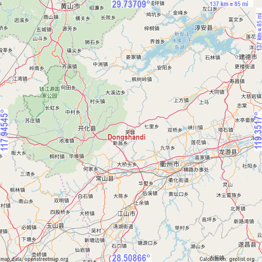
Dongshandi GPS coordinates[2]
29° 7' 28.956" North, 118° 38' 54.852" East
| Map corner | latitude | longitude |
|---|---|---|
| Upper-left | 29.73709°, | 117.94545° |
| Center: | 29.12471°, | 118.64857° |
| Lower-right: | 28.50866°, | 119.3517° |
| Map W x H: | 136.6×136.6 km | = 84.9×84.9mi |
| max Lat: | 53.31946° ⇑64% North |
| Dongshandi: | 29.12471° |
| min Lat: | ⇓36% South 18.22056° |
| min Long | Dongshandi | max Long |
| 75.07348° | 118.64857° | 134.28917° |
| W 74.1%⇐ | ⇒25.9% E |
Elevation
Elevation of Dongshandi is 241 m = 791 ft, and this is 243.8 m = 800 ft below average elevation for this country.
| Max E: |
5622 m = 18445 ft | 41.5% |
| Avg. | 484.8 m = 1591 ft | |
| Dongshandi | 241 m = 791 ft | |
Min E: |
-3 m = -10 ft | 58.5% |
See also: China elevation on elevation.city.
Geographical zone
Dongshandi is located in North temperate zone (between Tropic of Cancer and the Arctic Circle). Distance of this Northern Tropic circle is 632.4 km =393 mi to South.| Distance of | km | miles | from Dongshandi |
|---|---|---|---|
| North Pole | 6768.7 | 4205.9 | to North |
| Arctic Circle | 4162.8 | 2586.6 | to North |
| Tropic Cancer | 632.4 | 393 | to South |
| Equator | 3238.4 | 2012.2 | to South |


Nearby cities:
15 places around Dongshandi: (largest is in red/bold)
• Baima
14.7 km =9.1 mi,  26°
26°
• Datou
11.1 km =6.9 mi,  73°
73°
• Donglu
15.7 km =9.8 mi,  224°
224°
• Dongwu
15.6 km =9.7 mi,  321°
321°
• Dong’an
15.8 km =9.8 mi,  176°
176°
• Fangcun
8.5 km =5.3 mi,  203°
203°
• Furong
1.1 km =0.7 mi,  256°
256°
• Huanggu
19.4 km =12.1 mi,  333°
333°
• Jincun
18.3 km =11.4 mi,  290°
290°
• Shangsongfan
18.9 km =11.7 mi, 219°
• Shangyuan
8.6 km =5.3 mi, 175°
• Shiliang
17.5 km =10.9 mi,  131°
131°
• Xiacaoqiao
19.6 km =12.2 mi, 70°
• Xikou
14.9 km =9.3 mi,  279°
279°
• Xinchang
7.9 km =4.9 mi,  225°
225°
Sources, notices
• [Note1] Compared only with cities in China existing in our database
• [Src1] Map data: © OpenStreetMap contributors (CC-BY-SA)
• [Src2] Other city data from geonames.org with taken over terms of usage.
• [Src3] Geographical zone / Annual Mean Temperature by Robert A. Rohde @ Wikipedia
