Shangma geodata
Shangma (Zhejiang) is a seat of a fourth-order administrative division; located in China in Asia/Shanghai (GMT+8) time zone. In our database, there are 1268 cities with bigger population. Compared to other cities in China, 62.5% of cities are located further ↑North; 76.2% of cities are located further ←West and 58.5% of cities have higher elevation than Shangma. Note1


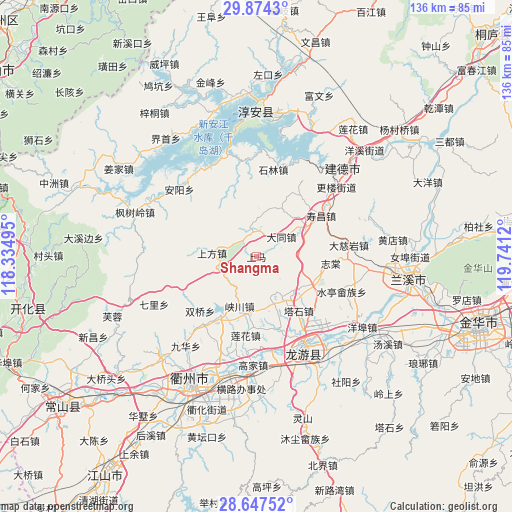
Shangma GPS coordinates[2]
29° 15' 45.9" North, 119° 2' 17.052" East
| Map corner | latitude | longitude |
|---|---|---|
| Upper-left | 29.8743°, | 118.33495° |
| Center: | 29.26275°, | 119.03807° |
| Lower-right: | 28.64752°, | 119.7412° |
| Map W x H: | 136.4×136.4 km | = 84.8×84.8mi |
| max Lat: | 53.31946° ⇑62.5% North |
| Shangma: | 29.26275° |
| min Lat: | ⇓37.5% South 18.22056° |
| min Long | Shangma | max Long |
| 75.07348° | 119.03807° | 134.28917° |
| W 76.2%⇐ | ⇒23.8% E |
Elevation
Elevation of Shangma is 108 m = 354 ft, and this is 376.8 m = 1236 ft below average elevation for this country.
| Max E: |
5622 m = 18445 ft | 58.5% |
| Avg. | 484.8 m = 1591 ft | |
| Shangma | 108 m = 354 ft | |
Min E: |
-3 m = -10 ft | 41.5% |
See also: China elevation on elevation.city.
Geographical zone
Shangma is located in North temperate zone (between Tropic of Cancer and the Arctic Circle). Distance of this Northern Tropic circle is 647.8 km =402.5 mi to South.| Distance of | km | miles | from Shangma |
|---|---|---|---|
| North Pole | 6753.3 | 4196.3 | to North |
| Arctic Circle | 4147.5 | 2577.1 | to North |
| Tropic Cancer | 647.8 | 402.5 | to South |
| Equator | 3253.7 | 2021.8 | to South |


Nearby cities:
15 places around Shangma: (largest is in red/bold)
• Datong
8.6 km =5.3 mi,  51°
51°
• Duze
17.8 km =11.1 mi,  210°
210°
• Hengshan
18.8 km =11.7 mi,  119°
119°
• Huipinggeng
17.9 km =11.1 mi,  265°
265°
• Lianhua
21.3 km =13.2 mi,  187°
187°
• Shangfang
11.9 km =7.4 mi, 273°
• Shifo
12.3 km =7.6 mi,  148°
148°
• Shouchang
20.5 km =12.7 mi,  58°
58°
• Shuangqiao
20.7 km =12.9 mi,  226°
226°
• Tashi
17.8 km =11.1 mi,  140°
140°
• Tongjia
19.8 km =12.3 mi,  31°
31°
• Xiacaoqiao
21.2 km =13.2 mi,  245°
245°
• Xiakou
14.1 km =8.8 mi,  200°
200°
• Zhitang
19.9 km =12.4 mi,  94°
94°
• Zhuge
24.5 km =15.2 mi, 92°
Sources, notices
• [Note1] Compared only with cities in China existing in our database
• [Src1] Map data: © OpenStreetMap contributors (CC-BY-SA)
• [Src2] Other city data from geonames.org with taken over terms of usage.
• [Src3] Geographical zone / Annual Mean Temperature by Robert A. Rohde @ Wikipedia
