Datong geodata
Datong (Zhejiang) is a seat of a fourth-order administrative division; located in China in Asia/Shanghai (GMT+8) time zone. In our database, there are 1268 cities with bigger population. Compared to other cities in China, 61.8% of cities are located further ↑North; 76.6% of cities are located further ←West and 62.4% of cities have higher elevation than Datong. Note1


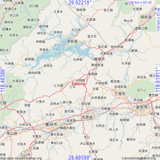
Datong GPS coordinates[2]
29° 18' 39.312" North, 119° 6' 25.128" East
| Map corner | latitude | longitude |
|---|---|---|
| Upper-left | 29.92218°, | 118.40386° |
| Center: | 29.31092°, | 119.10698° |
| Lower-right: | 28.69598°, | 119.81011° |
| Map W x H: | 136.3×136.3 km | = 84.7×84.7mi |
| max Lat: | 53.31946° ⇑61.8% North |
| Datong: | 29.31092° |
| min Lat: | ⇓38.2% South 18.22056° |
| min Long | Datong | max Long |
| 75.07348° | 119.10698° | 134.28917° |
| W 76.6%⇐ | ⇒23.4% E |
Elevation
Elevation of Datong is 85 m = 279 ft, and this is 399.8 m = 1312 ft below average elevation for this country.
| Max E: |
5622 m = 18445 ft | 62.4% |
| Avg. | 484.8 m = 1591 ft | |
| Datong | 85 m = 279 ft | |
Min E: |
-3 m = -10 ft | 37.6% |
See also: China elevation on elevation.city.
Geographical zone
Datong is located in North temperate zone (between Tropic of Cancer and the Arctic Circle). Distance of this Northern Tropic circle is 653.1 km =405.8 mi to South.| Distance of | km | miles | from Datong |
|---|---|---|---|
| North Pole | 6748 | 4193 | to North |
| Arctic Circle | 4142.1 | 2573.8 | to North |
| Tropic Cancer | 653.1 | 405.8 | to South |
| Equator | 3259.1 | 2025.1 | to South |


Nearby cities:
15 places around Datong: (largest is in red/bold)
• Hengshan
17.5 km =10.9 mi,  146°
146°
• Huipinggeng
25.4 km =15.8 mi,  254°
254°
• Liyang
22.1 km =13.7 mi,  329°
329°
• Shangfang
19.1 km =11.9 mi,  256°
256°
• Shangma
8.6 km =5.3 mi,  231°
231°
• Shifo
15.8 km =9.8 mi,  180°
180°
• Shouchang
12.1 km =7.5 mi,  63°
63°
• Shuiting
21.7 km =13.5 mi,  132°
132°
• Tangcun
18.9 km =11.7 mi,  98°
98°
• Tashi
19.6 km =12.2 mi,  166°
166°
• Tongjia
12.1 km =7.5 mi,  17°
17°
• Xiakou
21.9 km =13.6 mi,  212°
212°
• Xin’anjiang
24.2 km =15 mi,  41°
41°
• Zhitang
14.9 km =9.3 mi,  118°
118°
• Zhuge
19 km =11.8 mi,  110°
110°
Sources, notices
• [Note1] Compared only with cities in China existing in our database
• [Src1] Map data: © OpenStreetMap contributors (CC-BY-SA)
• [Src2] Other city data from geonames.org with taken over terms of usage.
• [Src3] Geographical zone / Annual Mean Temperature by Robert A. Rohde @ Wikipedia
