Zhongyang geodata
Zhongyang (Guangdong) is a seat of a fourth-order administrative division; located in China in Asia/Shanghai (GMT+8) time zone. In our database, there are 1268 cities with bigger population. Compared to other cities in China, 86.9% of cities are located further ↑North; 54.6% of cities are located further →East and 66.4% of cities have higher elevation than Zhongyang. Note1


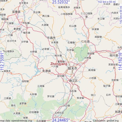
Zhongyang GPS coordinates[2]
24° 53' 2.868" North, 113° 27' 32.508" East
| Map corner | latitude | longitude |
|---|---|---|
| Upper-left | 25.52032°, | 112.75591° |
| Center: | 24.88413°, | 113.45903° |
| Lower-right: | 24.24465°, | 114.16216° |
| Map W x H: | 141.8×141.8 km | = 88.1×88.1mi |
| max Lat: | 53.31946° ⇑86.9% North |
| Zhongyang: | 24.88413° |
| min Lat: | ⇓13.1% South 18.22056° |
| min Long | Zhongyang | max Long |
| 75.07348° | 113.45903° | 134.28917° |
| W 45.4%⇐ | ⇒54.6% E |
Elevation
Elevation of Zhongyang is 67 m = 220 ft, and this is 417.8 m = 1371 ft below average elevation for this country.
| Max E: |
5622 m = 18445 ft | 66.4% |
| Avg. | 484.8 m = 1591 ft | |
| Zhongyang | 67 m = 220 ft | |
Min E: |
-3 m = -10 ft | 33.6% |
See also: China elevation on elevation.city.
Geographical zone
Zhongyang is located in North temperate zone (between Tropic of Cancer and the Arctic Circle). Distance of this Northern Tropic circle is 160.9 km =100 mi to South.| Distance of | km | miles | from Zhongyang |
|---|---|---|---|
| North Pole | 7240.2 | 4498.9 | to North |
| Arctic Circle | 4634.3 | 2879.6 | to North |
| Tropic Cancer | 160.9 | 100 | to South |
| Equator | 2766.9 | 1719.3 | to South |


Nearby cities:
15 places around Zhongyang: (largest is in red/bold)
• Baitu
23.1 km =14.4 mi,  165°
165°
• Bibei
22.8 km =14.2 mi,  307°
307°
• Guitou
6.9 km =4.3 mi,  322°
322°
• Huaping
18.4 km =11.4 mi,  38°
38°
• Leyuan
18.9 km =11.7 mi,  139°
139°
• Lishi
6.9 km =4.3 mi,  73°
73°
• Longgui
16.7 km =10.4 mi,  183°
183°
• Rucheng
22.3 km =13.9 mi,  238°
238°
• Shaoguan
15.6 km =9.7 mi,  126°
126°
• Shiliting
11.4 km =7.1 mi,  110°
110°
• Xihe
13.7 km =8.5 mi, 131°
• Xilian
15.7 km =9.8 mi,  150°
150°
• Xinshao
16.3 km =10.1 mi, 114°
• Yiliu
7.7 km =4.8 mi,  225°
225°
• Youxi
12.8 km =8 mi, 309°
Sources, notices
• [Note1] Compared only with cities in China existing in our database
• [Src1] Map data: © OpenStreetMap contributors (CC-BY-SA)
• [Src2] Other city data from geonames.org with taken over terms of usage.
• [Src3] Geographical zone / Annual Mean Temperature by Robert A. Rohde @ Wikipedia
