Guitou geodata
Guitou (Guangdong) is a seat of a fourth-order administrative division; located in China in Asia/Shanghai (GMT+8) time zone. In our database, there are 1268 cities with bigger population. Compared to other cities in China, 86.7% of cities are located further ↑North; 54.9% of cities are located further →East and 63.7% of cities have higher elevation than Guitou. Note1


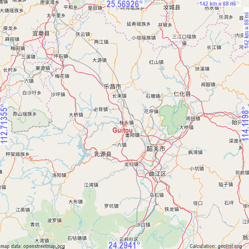
Guitou GPS coordinates[2]
24° 55' 59.988" North, 113° 25' 0.012" East
| Map corner | latitude | longitude |
|---|---|---|
| Upper-left | 25.56926°, | 112.71355° |
| Center: | 24.93333°, | 113.41667° |
| Lower-right: | 24.2941°, | 114.1198° |
| Map W x H: | 141.8×141.8 km | = 88.1×88.1mi |
| max Lat: | 53.31946° ⇑86.7% North |
| Guitou: | 24.93333° |
| min Lat: | ⇓13.3% South 18.22056° |
| min Long | Guitou | max Long |
| 75.07348° | 113.41667° | 134.28917° |
| W 45.1%⇐ | ⇒54.9% E |
Elevation
Elevation of Guitou is 79 m = 259 ft, and this is 405.8 m = 1331 ft below average elevation for this country.
| Max E: |
5622 m = 18445 ft | 63.7% |
| Avg. | 484.8 m = 1591 ft | |
| Guitou | 79 m = 259 ft | |
Min E: |
-3 m = -10 ft | 36.3% |
See also: China elevation on elevation.city.
Geographical zone
Guitou is located in North temperate zone (between Tropic of Cancer and the Arctic Circle). Distance of this Northern Tropic circle is 166.4 km =103.4 mi to South.| Distance of | km | miles | from Guitou |
|---|---|---|---|
| North Pole | 7234.7 | 4495.4 | to North |
| Arctic Circle | 4628.8 | 2876.2 | to North |
| Tropic Cancer | 166.4 | 103.4 | to South |
| Equator | 2772.3 | 1722.6 | to South |


Nearby cities:
15 places around Guitou: (largest is in red/bold)
• Bibei
16.2 km =10.1 mi,  301°
301°
• Changlai
17.1 km =10.6 mi,  352°
352°
• Huaping
18.1 km =11.2 mi,  60°
60°
• Lishi
11.5 km =7.1 mi,  108°
108°
• Longgui
22.3 km =13.9 mi,  171°
171°
• Rucheng
22.6 km =14 mi,  220°
220°
• Shaoguan
22.4 km =13.9 mi,  131°
131°
• Shiliting
17.7 km =11 mi,  122°
122°
• Shitang
21.9 km =13.6 mi,  43°
43°
• Xihe
20.5 km =12.7 mi, 134°
• Xilian
22.6 km =14 mi,  148°
148°
• Xinshao
22.7 km =14.1 mi, 122°
• Yiliu
10.9 km =6.8 mi,  186°
186°
• Youxi
6.3 km =3.9 mi,  294°
294°
• Zhongyang
6.9 km =4.3 mi,  142°
142°
Sources, notices
• [Note1] Compared only with cities in China existing in our database
• [Src1] Map data: © OpenStreetMap contributors (CC-BY-SA)
• [Src2] Other city data from geonames.org with taken over terms of usage.
• [Src3] Geographical zone / Annual Mean Temperature by Robert A. Rohde @ Wikipedia
