Fangqian geodata
Fangqian (Zhejiang) is a seat of a fourth-order administrative division; located in China in Asia/Shanghai (GMT+8) time zone. In our database, there are 1268 cities with bigger population. Compared to other cities in China, 64.8% of cities are located further ↑North; 86.1% of cities are located further ←West and 52.8% of cities have lower elevation than Fangqian. Note1


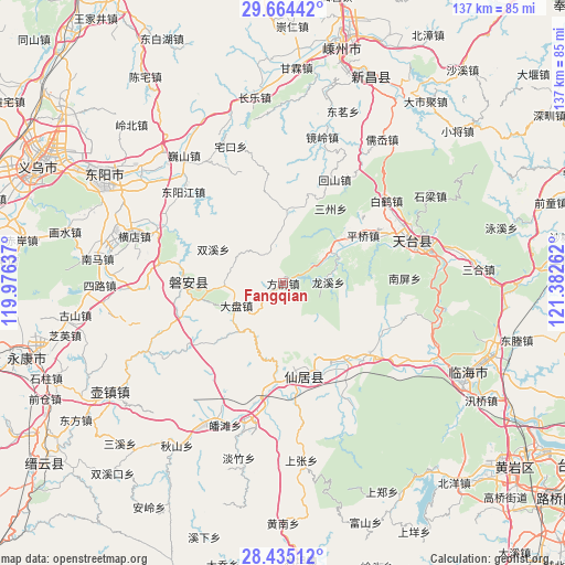
Fangqian GPS coordinates[2]
29° 3' 5.76" North, 120° 40' 46.164" East
| Map corner | latitude | longitude |
|---|---|---|
| Upper-left | 29.66442°, | 119.97637° |
| Center: | 29.0516°, | 120.67949° |
| Lower-right: | 28.43512°, | 121.38262° |
| Map W x H: | 136.7×136.7 km | = 84.9×84.9mi |
| max Lat: | 53.31946° ⇑64.8% North |
| Fangqian: | 29.0516° |
| min Lat: | ⇓35.2% South 18.22056° |
| min Long | Fangqian | max Long |
| 75.07348° | 120.67949° | 134.28917° |
| W 86.1%⇐ | ⇒13.9% E |
Elevation
Elevation of Fangqian is 187 m = 614 ft, and this is 297.8 m = 977 ft below average elevation for this country.
| Max E: |
5622 m = 18445 ft | 47.2% |
| Avg. | 484.8 m = 1591 ft | |
| Fangqian | 187 m = 614 ft | |
Min E: |
-3 m = -10 ft | 52.8% |
See also: China elevation on elevation.city.
Geographical zone
Fangqian is located in North temperate zone (between Tropic of Cancer and the Arctic Circle). Distance of this Northern Tropic circle is 624.3 km =387.9 mi to South.| Distance of | km | miles | from Fangqian |
|---|---|---|---|
| North Pole | 6776.8 | 4210.9 | to North |
| Arctic Circle | 4170.9 | 2591.7 | to North |
| Tropic Cancer | 624.3 | 387.9 | to South |
| Equator | 3230.2 | 2007.2 | to South |


Nearby cities:
15 places around Fangqian: (largest is in red/bold)
• Anwen
23.5 km =14.6 mi,  272°
272°
• Anzhou
19.7 km =12.2 mi,  169°
169°
• Fuying
21.4 km =13.3 mi, 169°
• Gao’er
17.2 km =10.7 mi,  214°
214°
• Guangdu
12.7 km =7.9 mi,  150°
150°
• Jianshan
19.6 km =12.2 mi,  10°
10°
• Jietou
14 km =8.7 mi,  59°
59°
• Nanfeng
22.2 km =13.8 mi, 165°
• Panfeng
18.5 km =11.5 mi,  227°
227°
• Pan’an
23.5 km =14.6 mi, 270°
• Pingqiao
22.6 km =14 mi, 60°
• Shanghu
11 km =6.8 mi,  346°
346°
• Weixin
14.7 km =9.1 mi, 205°
• Xianju
22.5 km =14 mi, 166°
• Xuetian
12.6 km =7.8 mi,  245°
245°
Sources, notices
• [Note1] Compared only with cities in China existing in our database
• [Src1] Map data: © OpenStreetMap contributors (CC-BY-SA)
• [Src2] Other city data from geonames.org with taken over terms of usage.
• [Src3] Geographical zone / Annual Mean Temperature by Robert A. Rohde @ Wikipedia
