Pingqiao geodata
Pingqiao (Zhejiang) is a seat of a fourth-order administrative division; located in China in Asia/Shanghai (GMT+8) time zone. In our database, there are 1268 cities with bigger population. Compared to other cities in China, 63.7% of cities are located further ↑North; 87.2% of cities are located further ←West and 64.3% of cities have higher elevation than Pingqiao. Note1


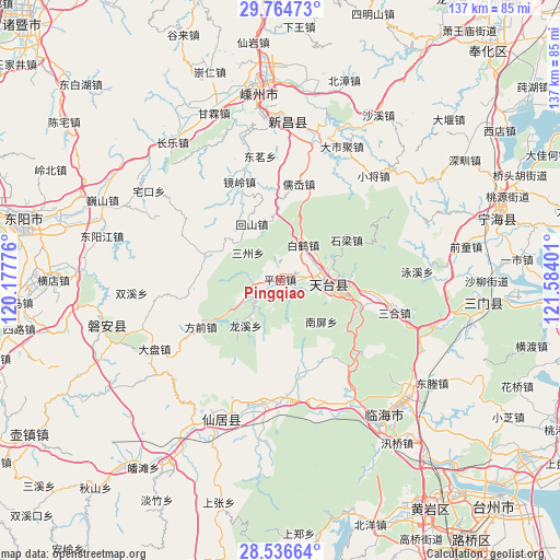
Pingqiao GPS coordinates[2]
29° 9' 9.072" North, 120° 52' 51.168" East
| Map corner | latitude | longitude |
|---|---|---|
| Upper-left | 29.76473°, | 120.17776° |
| Center: | 29.15252°, | 120.88088° |
| Lower-right: | 28.53664°, | 121.58401° |
| Map W x H: | 136.6×136.6 km | = 84.9×84.9mi |
| max Lat: | 53.31946° ⇑63.7% North |
| Pingqiao: | 29.15252° |
| min Lat: | ⇓36.3% South 18.22056° |
| min Long | Pingqiao | max Long |
| 75.07348° | 120.88088° | 134.28917° |
| W 87.2%⇐ | ⇒12.8% E |
Elevation
Elevation of Pingqiao is 76 m = 249 ft, and this is 408.8 m = 1341 ft below average elevation for this country.
| Max E: |
5622 m = 18445 ft | 64.3% |
| Avg. | 484.8 m = 1591 ft | |
| Pingqiao | 76 m = 249 ft | |
Min E: |
-3 m = -10 ft | 35.7% |
See also: China elevation on elevation.city.
Geographical zone
Pingqiao is located in North temperate zone (between Tropic of Cancer and the Arctic Circle). Distance of this Northern Tropic circle is 635.5 km =394.9 mi to South.| Distance of | km | miles | from Pingqiao |
|---|---|---|---|
| North Pole | 6765.6 | 4203.9 | to North |
| Arctic Circle | 4159.7 | 2584.7 | to North |
| Tropic Cancer | 635.5 | 394.9 | to South |
| Equator | 3241.5 | 2014.2 | to South |


Nearby cities:
15 places around Pingqiao: (largest is in red/bold)
• Baihedian
10.6 km =6.6 mi,  29°
29°
• Baishuiyang
28.4 km =17.6 mi,  177°
177°
• Dianqian
22.9 km =14.2 mi,  334°
334°
• Fangqian
22.6 km =14 mi,  240°
240°
• Guangdu
26 km =16.2 mi,  210°
210°
• Hetou
27.1 km =16.8 mi,  129°
129°
• Jianshan
17.9 km =11.1 mi,  296°
296°
• Jietou
8.5 km =5.3 mi, 241°
• Jingling
26.3 km =16.3 mi,  338°
338°
• Ru’ao
23.3 km =14.5 mi,  8°
8°
• Shanghu
22 km =13.7 mi,  268°
268°
• Shiliang
18.6 km =11.6 mi,  58°
58°
• Tantou
23.5 km =14.6 mi,  101°
101°
• Tiantai Chengguanzhen
14.6 km =9.1 mi, 97°
• Xinshichang
15.9 km =9.9 mi, 333°
Sources, notices
• [Note1] Compared only with cities in China existing in our database
• [Src1] Map data: © OpenStreetMap contributors (CC-BY-SA)
• [Src2] Other city data from geonames.org with taken over terms of usage.
• [Src3] Geographical zone / Annual Mean Temperature by Robert A. Rohde @ Wikipedia
