Guotian geodata
Guotian (Guangdong) is a seat of a fourth-order administrative division; located in China in Asia/Shanghai (GMT+8) time zone. In our database, there are 1268 cities with bigger population. Compared to other cities in China, 90.9% of cities are located further ↑North; 59.6% of cities are located further ←West and 56.5% of cities have lower elevation than Guotian. Note1


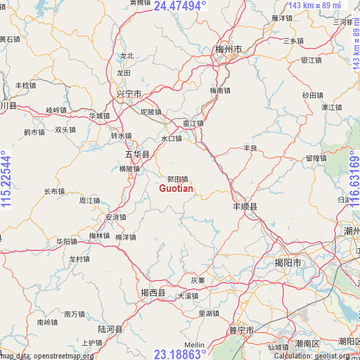
Guotian GPS coordinates[2]
23° 50' 0.168" North, 115° 55' 42.816" East
| Map corner | latitude | longitude |
|---|---|---|
| Upper-left | 24.47494°, | 115.22544° |
| Center: | 23.83338°, | 115.92856° |
| Lower-right: | 23.18863°, | 116.63169° |
| Map W x H: | 143×143 km | = 88.9×88.9mi |
| max Lat: | 53.31946° ⇑90.9% North |
| Guotian: | 23.83338° |
| min Lat: | ⇓9.1% South 18.22056° |
| min Long | Guotian | max Long |
| 75.07348° | 115.92856° | 134.28917° |
| W 59.6%⇐ | ⇒40.4% E |
Elevation
Elevation of Guotian is 221 m = 725 ft, and this is 263.8 m = 865 ft below average elevation for this country.
| Max E: |
5622 m = 18445 ft | 43.5% |
| Avg. | 484.8 m = 1591 ft | |
| Guotian | 221 m = 725 ft | |
Min E: |
-3 m = -10 ft | 56.5% |
See also: China elevation on elevation.city.
Geographical zone
Guotian is located in North temperate zone (between Tropic of Cancer and the Arctic Circle). Distance of this Northern Tropic circle is 44.1 km =27.4 mi to South.| Distance of | km | miles | from Guotian |
|---|---|---|---|
| North Pole | 7357 | 4571.4 | to North |
| Arctic Circle | 4751.2 | 2952.3 | to North |
| Tropic Cancer | 44.1 | 27.4 | to South |
| Equator | 2650 | 1646.6 | to South |


Nearby cities:
15 places around Guotian: (largest is in red/bold)
• Anliu
29.5 km =18.3 mi,  239°
239°
• Baxiangshan
8.4 km =5.2 mi,  148°
148°
• Beidou
20.7 km =12.9 mi,  93°
93°
• Hedong
17.9 km =11.1 mi,  302°
302°
• Hengpi
21.9 km =13.6 mi,  286°
286°
• Nibei
29.9 km =18.6 mi,  337°
337°
• Shejiang
23.6 km =14.7 mi,  12°
12°
• Shuanghua
16.5 km =10.3 mi,  224°
224°
• Shuiche
29.9 km =18.6 mi,  17°
17°
• Shuikou
17 km =10.6 mi,  348°
348°
• Shuizhai
19.8 km =12.3 mi, 302°
• Tangkeng
26 km =16.2 mi,  108°
108°
• Tangxi
24.3 km =15.1 mi, 110°
• Xinxu
25.6 km =15.9 mi, 345°
• Zhuanshui
29.9 km =18.6 mi,  308°
308°
Sources, notices
• [Note1] Compared only with cities in China existing in our database
• [Src1] Map data: © OpenStreetMap contributors (CC-BY-SA)
• [Src2] Other city data from geonames.org with taken over terms of usage.
• [Src3] Geographical zone / Annual Mean Temperature by Robert A. Rohde @ Wikipedia
