Baxiangshan geodata
Baxiangshan (Guangdong) is a seat of a fourth-order administrative division; located in China in Asia/Shanghai (GMT+8) time zone. In our database, there are 1268 cities with bigger population. Compared to other cities in China, 91% of cities are located further ↑North; 59.9% of cities are located further ←West and 79% of cities have lower elevation than Baxiangshan. Note1


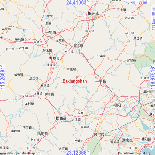
Baxiangshan GPS coordinates[2]
23° 46' 7.5" North, 115° 58' 19.308" East
| Map corner | latitude | longitude |
|---|---|---|
| Upper-left | 24.41063°, | 115.26891° |
| Center: | 23.76875°, | 115.97203° |
| Lower-right: | 23.12368°, | 116.67516° |
| Map W x H: | 143.1×143.1 km | = 88.9×88.9mi |
| max Lat: | 53.31946° ⇑91% North |
| Baxiangshan: | 23.76875° |
| min Lat: | ⇓9% South 18.22056° |
| min Long | Baxiangshan | max Long |
| 75.07348° | 115.97203° | 134.28917° |
| W 59.9%⇐ | ⇒40.1% E |
Elevation
Elevation of Baxiangshan is 652 m = 2139 ft, and this is 167.2 m = 549 ft above average elevation for this country.
| Max E: |
5622 m = 18445 ft | 21% |
| Baxiangshan | 652 m 2139 ft | |
| Avg. | 484.8 m = 1591 ft | |
Min E: |
-3 m = -10 ft | 79% |
See also: China elevation on elevation.city.
Geographical zone
Baxiangshan is located in North temperate zone (between Tropic of Cancer and the Arctic Circle). Distance of this Northern Tropic circle is 36.9 km =22.9 mi to South.| Distance of | km | miles | from Baxiangshan |
|---|---|---|---|
| North Pole | 7364.2 | 4575.9 | to North |
| Arctic Circle | 4758.3 | 2956.7 | to North |
| Tropic Cancer | 36.9 | 22.9 | to South |
| Equator | 2642.8 | 1642.2 | to South |


Nearby cities:
15 places around Baxiangshan: (largest is in red/bold)
• Beidou
17.3 km =10.7 mi,  69°
69°
• Buzhai
22.6 km =14 mi,  125°
125°
• Guotian
8.4 km =5.2 mi,  328°
328°
• Hedong
25.7 km =16 mi,  310°
310°
• Jingxiyuan
28.1 km =17.5 mi,  162°
162°
• Liangtian
27 km =16.8 mi,  207°
207°
• Longwei
27.9 km =17.3 mi,  140°
140°
• Shuanghua
16.6 km =10.3 mi,  254°
254°
• Shuikou
25.1 km =15.6 mi,  342°
342°
• Shuizhai
27.6 km =17.1 mi, 310°
• Tangkeng
20.3 km =12.6 mi,  93°
93°
• Tangnan
23.8 km =14.8 mi,  102°
102°
• Tangxi
18.4 km =11.4 mi, 93°
• Wujingfu
24.6 km =15.3 mi, 156°
• Yuhu
28.3 km =17.6 mi,  109°
109°
Sources, notices
• [Note1] Compared only with cities in China existing in our database
• [Src1] Map data: © OpenStreetMap contributors (CC-BY-SA)
• [Src2] Other city data from geonames.org with taken over terms of usage.
• [Src3] Geographical zone / Annual Mean Temperature by Robert A. Rohde @ Wikipedia
