Beidou geodata
Beidou (Guangdong) is a seat of a fourth-order administrative division; located in China in Asia/Shanghai (GMT+8) time zone. In our database, there are 1268 cities with bigger population. Compared to other cities in China, 90.9% of cities are located further ↑North; 60.8% of cities are located further ←West and 58.4% of cities have higher elevation than Beidou. Note1


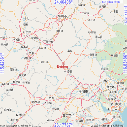
Beidou GPS coordinates[2]
23° 49' 20.892" North, 116° 7' 54.228" East
| Map corner | latitude | longitude |
|---|---|---|
| Upper-left | 24.46408°, | 115.42861° |
| Center: | 23.82247°, | 116.13173° |
| Lower-right: | 23.17767°, | 116.83486° |
| Map W x H: | 143×143 km | = 88.9×88.9mi |
| max Lat: | 53.31946° ⇑90.9% North |
| Beidou: | 23.82247° |
| min Lat: | ⇓9.1% South 18.22056° |
| min Long | Beidou | max Long |
| 75.07348° | 116.13173° | 134.28917° |
| W 60.8%⇐ | ⇒39.2% E |
Elevation
Elevation of Beidou is 109 m = 358 ft, and this is 375.8 m = 1233 ft below average elevation for this country.
| Max E: |
5622 m = 18445 ft | 58.4% |
| Avg. | 484.8 m = 1591 ft | |
| Beidou | 109 m = 358 ft | |
Min E: |
-3 m = -10 ft | 41.6% |
See also: China elevation on elevation.city.
Geographical zone
Beidou is located in North temperate zone (between Tropic of Cancer and the Arctic Circle). Distance of this Northern Tropic circle is 42.9 km =26.7 mi to South.| Distance of | km | miles | from Beidou |
|---|---|---|---|
| North Pole | 7358.3 | 4572.2 | to North |
| Arctic Circle | 4752.4 | 2953 | to North |
| Tropic Cancer | 42.9 | 26.7 | to South |
| Equator | 2648.8 | 1645.9 | to South |


Nearby cities:
15 places around Beidou: (largest is in red/bold)
• Baxiangshan
17.3 km =10.7 mi,  249°
249°
• Buzhai
19.3 km =12 mi,  173°
173°
• Fengliang
16.1 km =10 mi,  26°
26°
• Guiling
28.2 km =17.5 mi,  157°
157°
• Guotian
20.7 km =12.9 mi,  273°
273°
• Longgang
21.9 km =13.6 mi, 26°
• Longwei
27.5 km =17.1 mi,  176°
176°
• Pantian
22.2 km =13.8 mi,  61°
61°
• Shejiang
28.8 km =17.9 mi,  327°
327°
• Tangkeng
8.1 km =5 mi,  150°
150°
• Tangnan
13 km =8.1 mi, 147°
• Tangxi
7.5 km =4.7 mi, 163°
• Wujingfu
29.1 km =18.1 mi,  192°
192°
• Xinheng
25.8 km =16 mi,  142°
142°
• Yuhu
18.8 km =11.7 mi, 146°
Sources, notices
• [Note1] Compared only with cities in China existing in our database
• [Src1] Map data: © OpenStreetMap contributors (CC-BY-SA)
• [Src2] Other city data from geonames.org with taken over terms of usage.
• [Src3] Geographical zone / Annual Mean Temperature by Robert A. Rohde @ Wikipedia
