Beiwa geodata
Beiwa (Hebei) is a seat of a fourth-order administrative division; located in China in Asia/Shanghai (GMT+8) time zone. In our database, there are 1268 cities with bigger population. Compared to other cities in China, 81.5% of cities are located further ↓South; 51.2% of cities are located further ←West and 57.4% of cities have higher elevation than Beiwa. Note1


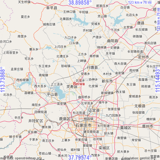
Beiwa GPS coordinates[2]
38° 20' 57.336" North, 114° 26' 30.48" East
| Map corner | latitude | longitude |
|---|---|---|
| Upper-left | 38.89858°, | 113.73868° |
| Center: | 38.34926°, | 114.4418° |
| Lower-right: | 37.79574°, | 115.14493° |
| Map W x H: | 122.6×122.6 km | = 76.2×76.2mi |
| max Lat: | 53.31946° ⇑18.5% North |
| Beiwa: | 38.34926° |
| min Lat: | ⇓81.5% South 18.22056° |
| min Long | Beiwa | max Long |
| 75.07348° | 114.4418° | 134.28917° |
| W 51.2%⇐ | ⇒48.8% E |
Elevation
Elevation of Beiwa is 115 m = 377 ft, and this is 369.8 m = 1213 ft below average elevation for this country.
| Max E: |
5622 m = 18445 ft | 57.4% |
| Avg. | 484.8 m = 1591 ft | |
| Beiwa | 115 m = 377 ft | |
Min E: |
-3 m = -10 ft | 42.6% |
See also: China elevation on elevation.city.
Geographical zone
Beiwa is located in North temperate zone (between Tropic of Cancer and the Arctic Circle). Distance of this Northern Tropic circle is 1658.1 km =1030.3 mi to South.| Distance of | km | miles | from Beiwa |
|---|---|---|---|
| North Pole | 5743 | 3568.5 | to North |
| Arctic Circle | 3137.1 | 1949.3 | to North |
| Tropic Cancer | 1658.1 | 1030.3 | to South |
| Equator | 4264 | 2649.5 | to South |


Nearby cities:
15 places around Beiwa: (largest is in red/bold)
• Anxiang
9.4 km =5.8 mi,  66°
66°
• Beizaoxian
14.9 km =9.3 mi,  151°
151°
• Diying
9.5 km =5.9 mi,  359°
359°
• Goutai
10.9 km =6.8 mi,  258°
258°
• Huapi
10.8 km =6.7 mi,  112°
112°
• Nanlou
12.8 km =8 mi,  134°
134°
• Nanzhai
5 km =3.1 mi,  298°
298°
• Niucheng
14.9 km =9.3 mi,  235°
235°
• Qingtong
8.9 km =5.5 mi,  294°
294°
• Quyangqiao
12.9 km =8 mi,  166°
166°
• Sanshengyuan
7.3 km =4.5 mi,  188°
188°
• Shangbei
15.1 km =9.4 mi,  5°
5°
• Shitong
10.3 km =6.4 mi,  30°
30°
• Xieshen
9.8 km =6.1 mi,  87°
87°
• Zhili
13.2 km =8.2 mi,  64°
64°
Sources, notices
• [Note1] Compared only with cities in China existing in our database
• [Src1] Map data: © OpenStreetMap contributors (CC-BY-SA)
• [Src2] Other city data from geonames.org with taken over terms of usage.
• [Src3] Geographical zone / Annual Mean Temperature by Robert A. Rohde @ Wikipedia
