Shangbei geodata
Shangbei (Hebei) is a seat of a fourth-order administrative division; located in China in Asia/Shanghai (GMT+8) time zone. In our database, there are 1268 cities with bigger population. Compared to other cities in China, 81.8% of cities are located further ↓South; 51.4% of cities are located further ←West and 55.7% of cities have higher elevation than Shangbei. Note1


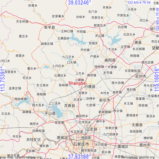
Shangbei GPS coordinates[2]
38° 29' 3.012" North, 114° 27' 25.308" East
| Map corner | latitude | longitude |
|---|---|---|
| Upper-left | 39.03246°, | 113.75391° |
| Center: | 38.48417°, | 114.45703° |
| Lower-right: | 37.93168°, | 115.16016° |
| Map W x H: | 122.4×122.4 km | = 76.1×76.1mi |
| max Lat: | 53.31946° ⇑18.2% North |
| Shangbei: | 38.48417° |
| min Lat: | ⇓81.8% South 18.22056° |
| min Long | Shangbei | max Long |
| 75.07348° | 114.45703° | 134.28917° |
| W 51.4%⇐ | ⇒48.6% E |
Elevation
Elevation of Shangbei is 126 m = 413 ft, and this is 358.8 m = 1177 ft below average elevation for this country.
| Max E: |
5622 m = 18445 ft | 55.7% |
| Avg. | 484.8 m = 1591 ft | |
| Shangbei | 126 m = 413 ft | |
Min E: |
-3 m = -10 ft | 44.3% |
See also: China elevation on elevation.city.
Geographical zone
Shangbei is located in North temperate zone (between Tropic of Cancer and the Arctic Circle). Distance of this Northern Tropic circle is 1673.1 km =1039.6 mi to South.| Distance of | km | miles | from Shangbei |
|---|---|---|---|
| North Pole | 5728 | 3559.2 | to North |
| Arctic Circle | 3122.1 | 1940 | to North |
| Tropic Cancer | 1673.1 | 1039.6 | to South |
| Equator | 4279 | 2658.8 | to South |


Nearby cities:
15 places around Shangbei: (largest is in red/bold)
• Anxiang
13.4 km =8.3 mi,  147°
147°
• Beitanzhuang
15.1 km =9.4 mi,  282°
282°
• Beiwa
15.1 km =9.4 mi,  185°
185°
• Chengzhai
10 km =6.2 mi,  301°
301°
• Ciyu
13.1 km =8.1 mi,  252°
252°
• Diying
5.7 km =3.5 mi,  195°
195°
• Duyanggang
11.9 km =7.4 mi,  107°
107°
• Koutou
14.8 km =9.2 mi,  334°
334°
• Nanqiao
9.8 km =6.1 mi,  69°
69°
• Nanzhai
13.9 km =8.6 mi, 204°
• Qingtong
14.6 km =9.1 mi,  219°
219°
• Shangfang
4.9 km =3 mi,  1°
1°
• Shitong
7.3 km =4.5 mi, 147°
• Yuting
7.4 km =4.6 mi,  38°
38°
• Zhili
14.1 km =8.8 mi,  131°
131°
Sources, notices
• [Note1] Compared only with cities in China existing in our database
• [Src1] Map data: © OpenStreetMap contributors (CC-BY-SA)
• [Src2] Other city data from geonames.org with taken over terms of usage.
• [Src3] Geographical zone / Annual Mean Temperature by Robert A. Rohde @ Wikipedia
