Lianmai geodata
Lianmai (Guangdong) is a seat of a fourth-order administrative division; located in China in Asia/Shanghai (GMT+8) time zone. In our database, there are 1268 cities with bigger population. Compared to other cities in China, 90.3% of cities are located further ↑North; 62% of cities are located further →East and 64.8% of cities have higher elevation than Lianmai. Note1


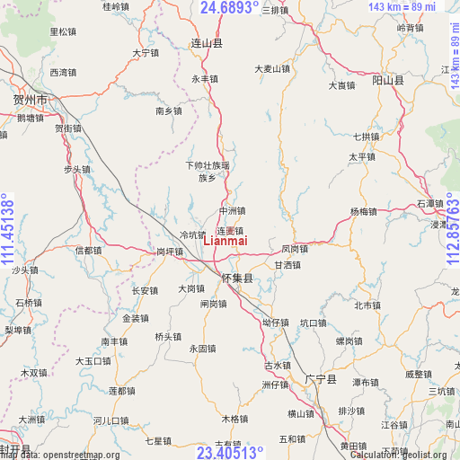
Lianmai GPS coordinates[2]
24° 2' 55.752" North, 112° 9' 16.2" East
| Map corner | latitude | longitude |
|---|---|---|
| Upper-left | 24.6893°, | 111.45138° |
| Center: | 24.04882°, | 112.1545° |
| Lower-right: | 23.40513°, | 112.85763° |
| Map W x H: | 142.8×142.8 km | = 88.7×88.7mi |
| max Lat: | 53.31946° ⇑90.3% North |
| Lianmai: | 24.04882° |
| min Lat: | ⇓9.7% South 18.22056° |
| min Long | Lianmai | max Long |
| 75.07348° | 112.1545° | 134.28917° |
| W 38%⇐ | ⇒62% E |
Elevation
Elevation of Lianmai is 74 m = 243 ft, and this is 410.8 m = 1348 ft below average elevation for this country.
| Max E: |
5622 m = 18445 ft | 64.8% |
| Avg. | 484.8 m = 1591 ft | |
| Lianmai | 74 m = 243 ft | |
Min E: |
-3 m = -10 ft | 35.2% |
See also: China elevation on elevation.city.
Geographical zone
Lianmai is located in North temperate zone (between Tropic of Cancer and the Arctic Circle). Distance of this Northern Tropic circle is 68.1 km =42.3 mi to South.| Distance of | km | miles | from Lianmai |
|---|---|---|---|
| North Pole | 7333.1 | 4556.6 | to North |
| Arctic Circle | 4727.2 | 2937.3 | to North |
| Tropic Cancer | 68.1 | 42.3 | to South |
| Equator | 2674 | 1661.5 | to South |


Nearby cities:
15 places around Lianmai: (largest is in red/bold)
• Dagang
22 km =13.7 mi,  213°
213°
• Fenggang
20.9 km =13 mi,  110°
110°
• Ganping
19.9 km =12.4 mi,  250°
250°
• Gansa
18.6 km =11.6 mi,  119°
119°
• Huaicheng
14.5 km =9 mi,  171°
171°
• Lanzhong
21 km =13 mi,  275°
275°
• Lengkeng
11.8 km =7.3 mi,  262°
262°
• Liangcun
18 km =11.2 mi,  232°
232°
• Maning
19.4 km =12.1 mi, 263°
• Qiashui
18.6 km =11.6 mi,  76°
76°
• Wenlang
14.8 km =9.2 mi, 119°
• Xiaosanjiang
24.9 km =15.5 mi,  353°
353°
• Xiashuai
21 km =13 mi,  337°
337°
• Zhagang
24.7 km =15.3 mi,  192°
192°
• Zhongzhou
6.3 km =3.9 mi,  6°
6°
Sources, notices
• [Note1] Compared only with cities in China existing in our database
• [Src1] Map data: © OpenStreetMap contributors (CC-BY-SA)
• [Src2] Other city data from geonames.org with taken over terms of usage.
• [Src3] Geographical zone / Annual Mean Temperature by Robert A. Rohde @ Wikipedia
