Gansa geodata
Gansa (Guangdong) is a seat of a fourth-order administrative division; located in China in Asia/Shanghai (GMT+8) time zone. In our database, there are 1268 cities with bigger population. Compared to other cities in China, 90.5% of cities are located further ↑North; 61.1% of cities are located further →East and 60.9% of cities have higher elevation than Gansa. Note1


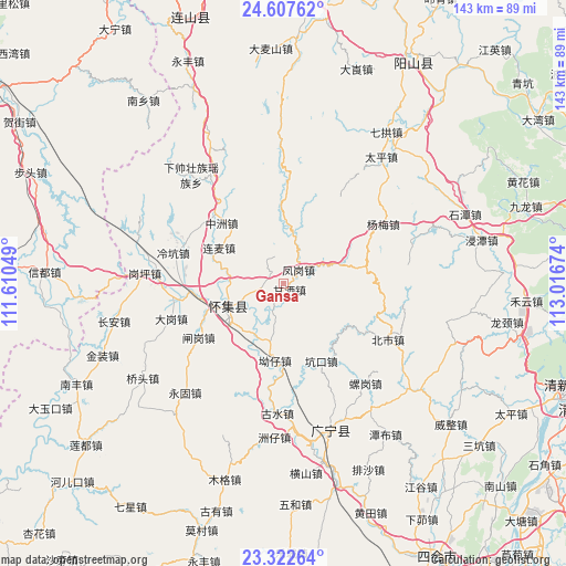
Gansa GPS coordinates[2]
23° 58' 0.228" North, 112° 18' 48.996" East
| Map corner | latitude | longitude |
|---|---|---|
| Upper-left | 24.60762°, | 111.61049° |
| Center: | 23.96673°, | 112.31361° |
| Lower-right: | 23.32264°, | 113.01674° |
| Map W x H: | 142.9×142.9 km | = 88.8×88.8mi |
| max Lat: | 53.31946° ⇑90.5% North |
| Gansa: | 23.96673° |
| min Lat: | ⇓9.5% South 18.22056° |
| min Long | Gansa | max Long |
| 75.07348° | 112.31361° | 134.28917° |
| W 38.9%⇐ | ⇒61.1% E |
Elevation
Elevation of Gansa is 93 m = 305 ft, and this is 391.8 m = 1285 ft below average elevation for this country.
| Max E: |
5622 m = 18445 ft | 60.9% |
| Avg. | 484.8 m = 1591 ft | |
| Gansa | 93 m = 305 ft | |
Min E: |
-3 m = -10 ft | 39.1% |
See also: China elevation on elevation.city.
Geographical zone
Gansa is located in North temperate zone (between Tropic of Cancer and the Arctic Circle). Distance of this Northern Tropic circle is 58.9 km =36.6 mi to South.| Distance of | km | miles | from Gansa |
|---|---|---|---|
| North Pole | 7342.2 | 4562.2 | to North |
| Arctic Circle | 4736.3 | 2943 | to North |
| Tropic Cancer | 58.9 | 36.6 | to South |
| Equator | 2664.9 | 1655.9 | to South |


Nearby cities:
15 places around Gansa: (largest is in red/bold)
• Aozai
19.4 km =12.1 mi,  182°
182°
• Beishi
29.8 km =18.5 mi,  118°
118°
• Chikeng
21 km =13 mi,  127°
127°
• Dagang
29.7 km =18.5 mi,  251°
251°
• Fenggang
4 km =2.5 mi,  60°
60°
• Huaicheng
14.9 km =9.3 mi, 249°
• Kengkou
21.7 km =13.5 mi,  156°
156°
• Lengkeng
28.9 km =18 mi,  285°
285°
• Liangcun
30.5 km =19 mi,  266°
266°
• Lianmai
18.6 km =11.6 mi,  299°
299°
• Qiashui
13.6 km =8.5 mi,  8°
8°
• Wenlang
3.8 km =2.4 mi, 300°
• Yangmei
28.9 km =18 mi, 59°
• Zhagang
26.3 km =16.3 mi,  235°
235°
• Zhongzhou
21.8 km =13.5 mi,  314°
314°
Sources, notices
• [Note1] Compared only with cities in China existing in our database
• [Src1] Map data: © OpenStreetMap contributors (CC-BY-SA)
• [Src2] Other city data from geonames.org with taken over terms of usage.
• [Src3] Geographical zone / Annual Mean Temperature by Robert A. Rohde @ Wikipedia
