Huaicheng geodata
Huaicheng (Guangdong) is a seat of a third-order administrative division; located in China in Asia/Shanghai (GMT+8) time zone. With population of 89,294 people, there are 478 cities with bigger population in this country. Compared to other cities in China, 90.7% of cities are located further ↑North; 61.8% of cities are located further →East and 68.2% of cities have higher elevation than Huaicheng. Note1


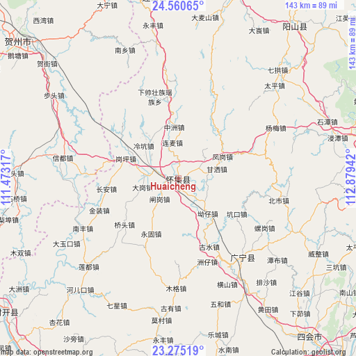
Huaicheng GPS coordinates[2]
23° 55' 10.272" North, 112° 10' 34.644" East
| Map corner | latitude | longitude |
|---|---|---|
| Upper-left | 24.56065°, | 111.47317° |
| Center: | 23.91952°, | 112.17629° |
| Lower-right: | 23.27519°, | 112.87942° |
| Map W x H: | 142.9×142.9 km | = 88.8×88.8mi |
| max Lat: | 53.31946° ⇑90.7% North |
| Huaicheng: | 23.91952° |
| min Lat: | ⇓9.3% South 18.22056° |
| min Long | Huaicheng | max Long |
| 75.07348° | 112.17629° | 134.28917° |
| W 38.2%⇐ | ⇒61.8% E |
Elevation
Elevation of Huaicheng is 59 m = 194 ft, and this is 425.8 m = 1397 ft below average elevation for this country.
| Max E: |
5622 m = 18445 ft | 68.2% |
| Avg. | 484.8 m = 1591 ft | |
| Huaicheng | 59 m = 194 ft | |
Min E: |
-3 m = -10 ft | 31.8% |
See also: Huaicheng elevation on elevation.city.
Geographical zone
Huaicheng is located in North temperate zone (between Tropic of Cancer and the Arctic Circle). Distance of this Northern Tropic circle is 53.7 km =33.4 mi to South.| Distance of | km | miles | from Huaicheng |
|---|---|---|---|
| North Pole | 7347.5 | 4565.5 | to North |
| Arctic Circle | 4741.6 | 2946.3 | to North |
| Tropic Cancer | 53.7 | 33.4 | to South |
| Equator | 2659.6 | 1652.6 | to South |


Nearby cities:
15 places around Huaicheng: (largest is in red/bold)
• Aozai
19.2 km =11.9 mi,  137°
137°
• Dagang
14.8 km =9.2 mi,  254°
254°
• Fenggang
18.8 km =11.7 mi,  67°
67°
• Ganping
22.3 km =13.9 mi,  289°
289°
• Gansa
14.9 km =9.3 mi, 69°
• Kengkou
27.1 km =16.8 mi,  122°
122°
• Lengkeng
18.9 km =11.7 mi,  312°
312°
• Liangcun
16.8 km =10.4 mi,  281°
281°
• Lianmai
14.5 km =9 mi,  351°
351°
• Maning
24.8 km =15.4 mi,  299°
299°
• Qiashui
24.5 km =15.2 mi,  40°
40°
• Wenlang
12.9 km =8 mi,  56°
56°
• Yonggu
25.1 km =15.6 mi,  205°
205°
• Zhagang
12.4 km =7.7 mi,  218°
218°
• Zhongzhou
20.7 km =12.9 mi,  355°
355°
Sources, notices
• [Note1] Compared only with cities in China existing in our database
• [Src1] Map data: © OpenStreetMap contributors (CC-BY-SA)
• [Src2] Other city data from geonames.org with taken over terms of usage.
• [Src3] Geographical zone / Annual Mean Temperature by Robert A. Rohde @ Wikipedia
