Liangcun geodata
Liangcun (Guangdong) is a seat of a fourth-order administrative division; located in China in Asia/Shanghai (GMT+8) time zone. In our database, there are 1268 cities with bigger population. Compared to other cities in China, 90.6% of cities are located further ↑North; 62.7% of cities are located further →East and 67.4% of cities have higher elevation than Liangcun. Note1


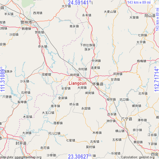
Liangcun GPS coordinates[2]
23° 57' 1.584" North, 112° 0' 50.436" East
| Map corner | latitude | longitude |
|---|---|---|
| Upper-left | 24.59141°, | 111.31089° |
| Center: | 23.95044°, | 112.01401° |
| Lower-right: | 23.30627°, | 112.71714° |
| Map W x H: | 142.9×142.9 km | = 88.8×88.8mi |
| max Lat: | 53.31946° ⇑90.6% North |
| Liangcun: | 23.95044° |
| min Lat: | ⇓9.4% South 18.22056° |
| min Long | Liangcun | max Long |
| 75.07348° | 112.01401° | 134.28917° |
| W 37.3%⇐ | ⇒62.7% E |
Elevation
Elevation of Liangcun is 63 m = 207 ft, and this is 421.8 m = 1384 ft below average elevation for this country.
| Max E: |
5622 m = 18445 ft | 67.4% |
| Avg. | 484.8 m = 1591 ft | |
| Liangcun | 63 m = 207 ft | |
Min E: |
-3 m = -10 ft | 32.6% |
See also: China elevation on elevation.city.
Geographical zone
Liangcun is located in North temperate zone (between Tropic of Cancer and the Arctic Circle). Distance of this Northern Tropic circle is 57.1 km =35.5 mi to South.| Distance of | km | miles | from Liangcun |
|---|---|---|---|
| North Pole | 7344 | 4563.3 | to North |
| Arctic Circle | 4738.1 | 2944.1 | to North |
| Tropic Cancer | 57.1 | 35.5 | to South |
| Equator | 2663 | 1654.7 | to South |


Nearby cities:
15 places around Liangcun: (largest is in red/bold)
• Chang’an
14.4 km =8.9 mi,  238°
238°
• Dagang
7.8 km =4.8 mi,  163°
163°
• Ganping
6.1 km =3.8 mi,  312°
312°
• Gansa
30.5 km =19 mi,  86°
86°
• Huaicheng
16.8 km =10.4 mi,  101°
101°
• Jinzhuang
22.4 km =13.9 mi,  222°
222°
• Lanzhong
14.4 km =8.9 mi,  332°
332°
• Lengkeng
9.6 km =6 mi,  15°
15°
• Lianmai
18 km =11.2 mi,  52°
52°
• Maning
10.2 km =6.3 mi, 330°
• Qiaotou
23.3 km =14.5 mi,  191°
191°
• Wenlang
27.4 km =17 mi,  82°
82°
• Yonggu
26.6 km =16.5 mi,  167°
167°
• Zhagang
15.8 km =9.8 mi,  146°
146°
• Zhongzhou
22.8 km =14.2 mi,  40°
40°
Sources, notices
• [Note1] Compared only with cities in China existing in our database
• [Src1] Map data: © OpenStreetMap contributors (CC-BY-SA)
• [Src2] Other city data from geonames.org with taken over terms of usage.
• [Src3] Geographical zone / Annual Mean Temperature by Robert A. Rohde @ Wikipedia
