Wan’an geodata
Wan’an (Fujian) is a seat of a fourth-order administrative division; located in China in Asia/Shanghai (GMT+8) time zone. In our database, there are 1268 cities with bigger population. Compared to other cities in China, 79% of cities are located further ↑North; 68.4% of cities are located further ←West and 61% of cities have lower elevation than Wan’an. Note1


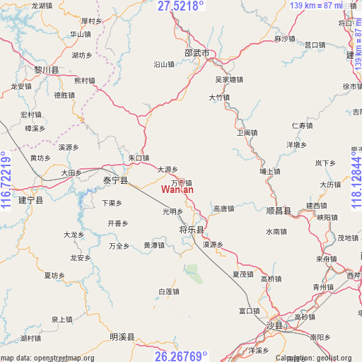
Wan’an GPS coordinates[2]
26° 53' 47.364" North, 117° 25' 31.116" East
| Map corner | latitude | longitude |
|---|---|---|
| Upper-left | 27.5218°, | 116.72219° |
| Center: | 26.89649°, | 117.42531° |
| Lower-right: | 26.26769°, | 118.12844° |
| Map W x H: | 139.4×139.4 km | = 86.6×86.6mi |
| max Lat: | 53.31946° ⇑79% North |
| Wan’an: | 26.89649° |
| min Lat: | ⇓21% South 18.22056° |
| min Long | Wan’an | max Long |
| 75.07348° | 117.42531° | 134.28917° |
| W 68.4%⇐ | ⇒31.6% E |
Elevation
Elevation of Wan’an is 271 m = 889 ft, and this is 213.8 m = 701 ft below average elevation for this country.
| Max E: |
5622 m = 18445 ft | 39% |
| Avg. | 484.8 m = 1591 ft | |
| Wan’an | 271 m = 889 ft | |
Min E: |
-3 m = -10 ft | 61% |
See also: China elevation on elevation.city.
Geographical zone
Wan’an is located in North temperate zone (between Tropic of Cancer and the Arctic Circle). Distance of this Northern Tropic circle is 384.7 km =239 mi to South.| Distance of | km | miles | from Wan’an |
|---|---|---|---|
| North Pole | 7016.5 | 4359.8 | to North |
| Arctic Circle | 4410.6 | 2740.6 | to North |
| Tropic Cancer | 384.7 | 239 | to South |
| Equator | 2990.6 | 1858.3 | to South |


Nearby cities:
15 places around Wan’an: (largest is in red/bold)
• Anren
8.1 km =5 mi,  4°
4°
• Dagan
30.7 km =19.1 mi,  82°
82°
• Dayuan
7.1 km =4.4 mi,  313°
313°
• Gaotang
19.1 km =11.9 mi,  122°
122°
• Guangming
11.8 km =7.3 mi,  197°
197°
• Guyong
18.9 km =11.7 mi,  166°
166°
• Hongdun
25.6 km =15.9 mi,  69°
69°
• Huangtan
26.5 km =16.5 mi, 203°
• Kaishan
29.1 km =18.1 mi,  236°
236°
• Moyuan
27.2 km =16.9 mi,  152°
152°
• Nankou
30.1 km =18.7 mi,  181°
181°
• Shancheng
26 km =16.2 mi,  270°
270°
• Xiaqu
27.9 km =17.3 mi,  253°
253°
• Yufang
16.9 km =10.5 mi, 272°
• Zhukou
18.7 km =11.6 mi,  299°
299°
Sources, notices
• [Note1] Compared only with cities in China existing in our database
• [Src1] Map data: © OpenStreetMap contributors (CC-BY-SA)
• [Src2] Other city data from geonames.org with taken over terms of usage.
• [Src3] Geographical zone / Annual Mean Temperature by Robert A. Rohde @ Wikipedia
