Taoxi geodata
Taoxi (Fujian) is a seat of a fourth-order administrative division; located in China in Asia/Shanghai (GMT+8) time zone. In our database, there are 1268 cities with bigger population. Compared to other cities in China, 84.8% of cities are located further ↑North; 61.1% of cities are located further ←West and 63.7% of cities have lower elevation than Taoxi. Note1


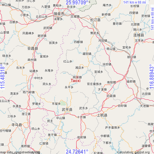
Taoxi GPS coordinates[2]
25° 21' 48.312" North, 116° 11' 10.68" East
| Map corner | latitude | longitude |
|---|---|---|
| Upper-left | 25.99709°, | 115.48318° |
| Center: | 25.36342°, | 116.1863° |
| Lower-right: | 24.72641°, | 116.88943° |
| Map W x H: | 141.3×141.3 km | = 87.8×87.8mi |
| max Lat: | 53.31946° ⇑84.8% North |
| Taoxi: | 25.36342° |
| min Lat: | ⇓15.2% South 18.22056° |
| min Long | Taoxi | max Long |
| 75.07348° | 116.1863° | 134.28917° |
| W 61.1%⇐ | ⇒38.9% E |
Elevation
Elevation of Taoxi is 307 m = 1007 ft, and this is 177.8 m = 583 ft below average elevation for this country.
| Max E: |
5622 m = 18445 ft | 36.3% |
| Avg. | 484.8 m = 1591 ft | |
| Taoxi | 307 m = 1007 ft | |
Min E: |
-3 m = -10 ft | 63.7% |
See also: China elevation on elevation.city.
Geographical zone
Taoxi is located in North temperate zone (between Tropic of Cancer and the Arctic Circle). Distance of this Northern Tropic circle is 214.2 km =133.1 mi to South.| Distance of | km | miles | from Taoxi |
|---|---|---|---|
| North Pole | 7186.9 | 4465.7 | to North |
| Arctic Circle | 4581 | 2846.5 | to North |
| Tropic Cancer | 214.2 | 133.1 | to South |
| Equator | 2820.1 | 1752.3 | to South |


Nearby cities:
15 places around Taoxi: (largest is in red/bold)
• Dahe
9.5 km =5.9 mi,  295°
295°
• Dongtou
28.4 km =17.6 mi,  257°
257°
• Guanzhuang
17 km =10.6 mi,  110°
110°
• Hongshan
16.9 km =10.5 mi,  330°
330°
• Shangcai Zhongxing
25.6 km =15.9 mi,  115°
115°
• Shanhu
20.4 km =12.7 mi,  136°
136°
• Tongxian
28 km =17.4 mi,  104°
104°
• Wan’an
27.1 km =16.8 mi,  200°
200°
• Xiangdian
9.2 km =5.7 mi,  14°
14°
• Xuancheng
20.5 km =12.7 mi,  75°
75°
• Yanggu
13.3 km =8.3 mi, 79°
• Yonglong
26.3 km =16.3 mi,  283°
283°
• Yongping
11.6 km =7.2 mi,  218°
218°
• Zhongbao
20.3 km =12.6 mi,  156°
156°
• Zhuotian
23.4 km =14.5 mi,  22°
22°
Sources, notices
• [Note1] Compared only with cities in China existing in our database
• [Src1] Map data: © OpenStreetMap contributors (CC-BY-SA)
• [Src2] Other city data from geonames.org with taken over terms of usage.
• [Src3] Geographical zone / Annual Mean Temperature by Robert A. Rohde @ Wikipedia
