Bai’e geodata
Bai’e (Jiangxi) is a seat of a fourth-order administrative division; located in China in Asia/Shanghai (GMT+8) time zone. In our database, there are 1268 cities with bigger population. Compared to other cities in China, 83.1% of cities are located further ↑North; 57.6% of cities are located further ←West and 50.9% of cities have higher elevation than Bai’e. Note1


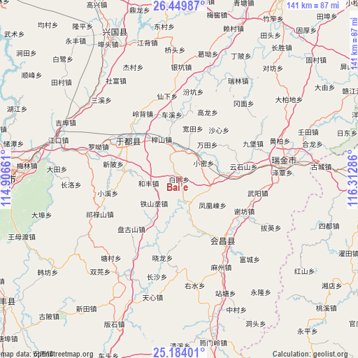
Bai’e GPS coordinates[2]
25° 49' 7.068" North, 115° 36' 35.028" East
| Map corner | latitude | longitude |
|---|---|---|
| Upper-left | 26.44987°, | 114.90661° |
| Center: | 25.81863°, | 115.60973° |
| Lower-right: | 25.18401°, | 116.31286° |
| Map W x H: | 140.8×140.8 km | = 87.5×87.5mi |
| max Lat: | 53.31946° ⇑83.1% North |
| Bai’e: | 25.81863° |
| min Lat: | ⇓16.9% South 18.22056° |
| min Long | Bai’e | max Long |
| 75.07348° | 115.60973° | 134.28917° |
| W 57.6%⇐ | ⇒42.4% E |
Elevation
Elevation of Bai’e is 157 m = 515 ft, and this is 327.8 m = 1075 ft below average elevation for this country.
| Max E: |
5622 m = 18445 ft | 50.9% |
| Avg. | 484.8 m = 1591 ft | |
| Bai’e | 157 m = 515 ft | |
Min E: |
-3 m = -10 ft | 49.1% |
See also: China elevation on elevation.city.
Geographical zone
Bai’e is located in North temperate zone (between Tropic of Cancer and the Arctic Circle). Distance of this Northern Tropic circle is 264.8 km =164.5 mi to South.| Distance of | km | miles | from Bai’e |
|---|---|---|---|
| North Pole | 7136.3 | 4434.3 | to North |
| Arctic Circle | 4530.4 | 2815.1 | to North |
| Tropic Cancer | 264.8 | 164.5 | to South |
| Equator | 2870.8 | 1783.8 | to South |


Nearby cities:
15 places around Bai’e: (largest is in red/bold)
• Fenghuangdong
16.6 km =10.3 mi,  127°
127°
• Hefeng
12.3 km =7.6 mi,  260°
260°
• Huanglin
11.1 km =6.9 mi,  5°
5°
• Jingshi
20.2 km =12.6 mi,  214°
214°
• Kuantian
20.7 km =12.9 mi,  15°
15°
• Licun
21.9 km =13.6 mi,  278°
278°
• Shaxin
25 km =15.5 mi,  38°
38°
• Tieshanlong
13.7 km =8.5 mi,  226°
226°
• Wantian
17.6 km =10.9 mi, 39°
• Xiaomi
11.6 km =7.2 mi,  56°
56°
• Xijiang
17.2 km =10.7 mi,  83°
83°
• Zhuangbu
13.5 km =8.4 mi,  186°
186°
• Zhuangkou
10 km =6.2 mi,  152°
152°
• Zhulan
23.6 km =14.7 mi, 154°
• Zishan
17.1 km =10.6 mi,  336°
336°
Sources, notices
• [Note1] Compared only with cities in China existing in our database
• [Src1] Map data: © OpenStreetMap contributors (CC-BY-SA)
• [Src2] Other city data from geonames.org with taken over terms of usage.
• [Src3] Geographical zone / Annual Mean Temperature by Robert A. Rohde @ Wikipedia
