Changqiao geodata
Changqiao (Jiangxi) is a seat of a fourth-order administrative division; located in China in Asia/Shanghai (GMT+8) time zone. In our database, there are 1268 cities with bigger population. Compared to other cities in China, 79.3% of cities are located further ↑North; 62.5% of cities are located further ←West and 53.3% of cities have lower elevation than Changqiao. Note1


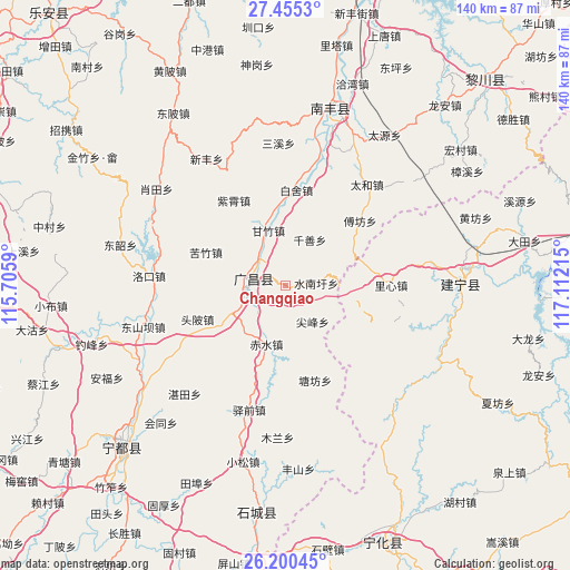
Changqiao GPS coordinates[2]
26° 49' 46.596" North, 116° 24' 32.472" East
| Map corner | latitude | longitude |
|---|---|---|
| Upper-left | 27.4553°, | 115.7059° |
| Center: | 26.82961°, | 116.40902° |
| Lower-right: | 26.20045°, | 117.11215° |
| Map W x H: | 139.5×139.5 km | = 86.7×86.7mi |
| max Lat: | 53.31946° ⇑79.3% North |
| Changqiao: | 26.82961° |
| min Lat: | ⇓20.7% South 18.22056° |
| min Long | Changqiao | max Long |
| 75.07348° | 116.40902° | 134.28917° |
| W 62.5%⇐ | ⇒37.5% E |
Elevation
Elevation of Changqiao is 191 m = 627 ft, and this is 293.8 m = 964 ft below average elevation for this country.
| Max E: |
5622 m = 18445 ft | 46.7% |
| Avg. | 484.8 m = 1591 ft | |
| Changqiao | 191 m = 627 ft | |
Min E: |
-3 m = -10 ft | 53.3% |
See also: China elevation on elevation.city.
Geographical zone
Changqiao is located in North temperate zone (between Tropic of Cancer and the Arctic Circle). Distance of this Northern Tropic circle is 377.3 km =234.4 mi to South.| Distance of | km | miles | from Changqiao |
|---|---|---|---|
| North Pole | 7023.9 | 4364.4 | to North |
| Arctic Circle | 4418 | 2745.2 | to North |
| Tropic Cancer | 377.3 | 234.4 | to South |
| Equator | 2983.2 | 1853.7 | to South |


Nearby cities:
15 places around Changqiao: (largest is in red/bold)
• Baishe
23.6 km =14.7 mi,  6°
6°
• Chishui
15 km =9.3 mi,  197°
197°
• Fufang
24.3 km =15.1 mi,  49°
49°
• Huangbu
26.1 km =16.2 mi,  111°
111°
• Jianfeng
11 km =6.8 mi,  142°
142°
• Kefang
21.6 km =13.4 mi,  125°
125°
• Kuzhu
21.1 km =13.1 mi,  292°
292°
• Lixin
25.9 km =16.1 mi,  89°
89°
• Qianshan
12.8 km =8 mi,  28°
28°
• Shuinanxu
7.6 km =4.7 mi, 85°
• Tangfang
24.3 km =15.1 mi,  162°
162°
• Toupi
23 km =14.3 mi,  249°
249°
• Xujiang
8.9 km =5.5 mi,  277°
277°
• Yangxi
23.2 km =14.4 mi,  184°
184°
• Zixiao
24.4 km =15.2 mi,  329°
329°
Sources, notices
• [Note1] Compared only with cities in China existing in our database
• [Src1] Map data: © OpenStreetMap contributors (CC-BY-SA)
• [Src2] Other city data from geonames.org with taken over terms of usage.
• [Src3] Geographical zone / Annual Mean Temperature by Robert A. Rohde @ Wikipedia
