Hengshan geodata
Hengshan (Jiangxi) is a seat of a fourth-order administrative division; located in China in Asia/Shanghai (GMT+8) time zone. In our database, there are 1268 cities with bigger population. Compared to other cities in China, 71.3% of cities are located further ↑North; 71.5% of cities are located further ←West and 50.2% of cities have higher elevation than Hengshan. Note1


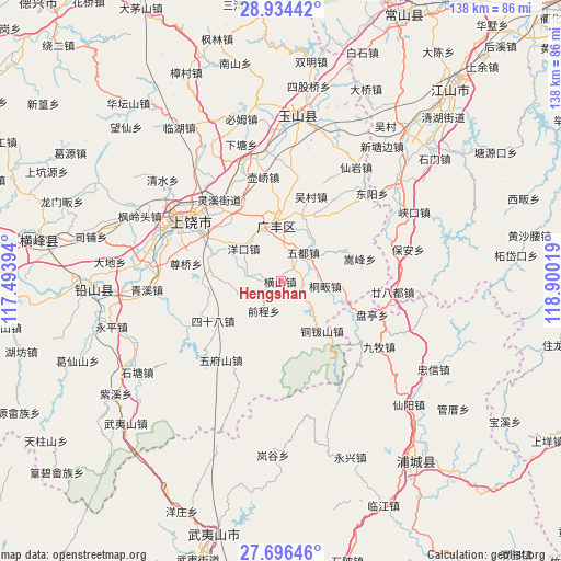
Hengshan GPS coordinates[2]
28° 19' 2.064" North, 118° 11' 49.416" East
| Map corner | latitude | longitude |
|---|---|---|
| Upper-left | 28.93442°, | 117.49394° |
| Center: | 28.31724°, | 118.19706° |
| Lower-right: | 27.69646°, | 118.90019° |
| Map W x H: | 137.6×137.6 km | = 85.5×85.5mi |
| max Lat: | 53.31946° ⇑71.3% North |
| Hengshan: | 28.31724° |
| min Lat: | ⇓28.7% South 18.22056° |
| min Long | Hengshan | max Long |
| 75.07348° | 118.19706° | 134.28917° |
| W 71.5%⇐ | ⇒28.5% E |
Elevation
Elevation of Hengshan is 163 m = 535 ft, and this is 321.8 m = 1056 ft below average elevation for this country.
| Max E: |
5622 m = 18445 ft | 50.2% |
| Avg. | 484.8 m = 1591 ft | |
| Hengshan | 163 m = 535 ft | |
Min E: |
-3 m = -10 ft | 49.8% |
See also: China elevation on elevation.city.
Geographical zone
Hengshan is located in North temperate zone (between Tropic of Cancer and the Arctic Circle). Distance of this Northern Tropic circle is 542.7 km =337.2 mi to South.| Distance of | km | miles | from Hengshan |
|---|---|---|---|
| North Pole | 6858.5 | 4261.7 | to North |
| Arctic Circle | 4252.6 | 2642.4 | to North |
| Tropic Cancer | 542.7 | 337.2 | to South |
| Equator | 3148.6 | 1956.4 | to South |


Nearby cities:
15 places around Hengshan: (largest is in red/bold)
• Chaoyang
18.8 km =11.7 mi,  318°
318°
• Dashi
9.6 km =6 mi,  8°
8°
• Gaozhou
24.2 km =15 mi,  209°
209°
• Lingdi
15.9 km =9.9 mi,  141°
141°
• Maocun
18.5 km =11.5 mi,  62°
62°
• Paishan
17.8 km =11.1 mi,  26°
26°
• Quanbo
15.2 km =9.4 mi, 62°
• Shatian
8.5 km =5.3 mi,  74°
74°
• Sishiba
19.2 km =11.9 mi,  239°
239°
• Songfeng
19.8 km =12.3 mi,  76°
76°
• Tieshan
15.1 km =9.4 mi,  221°
221°
• Tongfan
11.1 km =6.9 mi,  95°
95°
• Wucun
21.7 km =13.5 mi,  21°
21°
• Xiaxi
15.9 km =9.9 mi,  356°
356°
• Yongfeng
11.4 km =7.1 mi, 8°
Sources, notices
• [Note1] Compared only with cities in China existing in our database
• [Src1] Map data: © OpenStreetMap contributors (CC-BY-SA)
• [Src2] Other city data from geonames.org with taken over terms of usage.
• [Src3] Geographical zone / Annual Mean Temperature by Robert A. Rohde @ Wikipedia
