Dongtuan geodata
Dongtuan (Jiangxi) is a seat of a fourth-order administrative division; located in China in Asia/Shanghai (GMT+8) time zone. In our database, there are 1268 cities with bigger population. Compared to other cities in China, 70.7% of cities are located further ↑North; 70% of cities are located further ←West and 62.6% of cities have higher elevation than Dongtuan. Note1


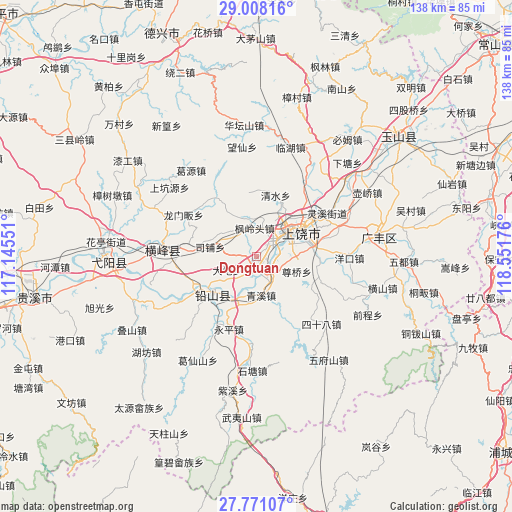
Dongtuan GPS coordinates[2]
28° 23' 29.112" North, 117° 50' 55.068" East
| Map corner | latitude | longitude |
|---|---|---|
| Upper-left | 29.00816°, | 117.14551° |
| Center: | 28.39142°, | 117.84863° |
| Lower-right: | 27.77107°, | 118.55176° |
| Map W x H: | 137.6×137.6 km | = 85.5×85.5mi |
| max Lat: | 53.31946° ⇑70.7% North |
| Dongtuan: | 28.39142° |
| min Lat: | ⇓29.3% South 18.22056° |
| min Long | Dongtuan | max Long |
| 75.07348° | 117.84863° | 134.28917° |
| W 70%⇐ | ⇒30% E |
Elevation
Elevation of Dongtuan is 84 m = 276 ft, and this is 400.8 m = 1315 ft below average elevation for this country.
| Max E: |
5622 m = 18445 ft | 62.6% |
| Avg. | 484.8 m = 1591 ft | |
| Dongtuan | 84 m = 276 ft | |
Min E: |
-3 m = -10 ft | 37.4% |
See also: China elevation on elevation.city.
Geographical zone
Dongtuan is located in North temperate zone (between Tropic of Cancer and the Arctic Circle). Distance of this Northern Tropic circle is 550.9 km =342.3 mi to South.| Distance of | km | miles | from Dongtuan |
|---|---|---|---|
| North Pole | 6850.2 | 4256.5 | to North |
| Arctic Circle | 4244.3 | 2637.3 | to North |
| Tropic Cancer | 550.9 | 342.3 | to South |
| Equator | 3156.8 | 1961.5 | to South |


Nearby cities:
15 places around Dongtuan: (largest is in red/bold)
• Bangluo
10.9 km =6.8 mi,  209°
209°
• Chating
5.5 km =3.4 mi,  135°
135°
• Ehu
12.4 km =7.7 mi, 205°
• Fenglingtou
8 km =5 mi,  357°
357°
• Gangbian
17.7 km =11 mi,  298°
298°
• Hekou
16.1 km =10 mi,  238°
238°
• Huangshaling
19.3 km =12 mi,  148°
148°
• Qingshui
17.6 km =10.9 mi,  11°
11°
• Qingxi
9.8 km =6.1 mi,  171°
171°
• Shangrao
11.4 km =7.1 mi,  53°
53°
• Shishi
17.3 km =10.7 mi,  44°
44°
• Sipu
14.5 km =9 mi,  289°
289°
• Xintan
17.8 km =11.1 mi,  248°
248°
• Xuri
8.5 km =5.3 mi,  55°
55°
• Yongping
20.8 km =12.9 mi,  199°
199°
Sources, notices
• [Note1] Compared only with cities in China existing in our database
• [Src1] Map data: © OpenStreetMap contributors (CC-BY-SA)
• [Src2] Other city data from geonames.org with taken over terms of usage.
• [Src3] Geographical zone / Annual Mean Temperature by Robert A. Rohde @ Wikipedia
