Huangshaling geodata
Huangshaling (Jiangxi) is a seat of a fourth-order administrative division; located in China in Asia/Shanghai (GMT+8) time zone. In our database, there are 1268 cities with bigger population. Compared to other cities in China, 72% of cities are located further ↑North; 70.4% of cities are located further ←West and 52.4% of cities have higher elevation than Huangshaling. Note1


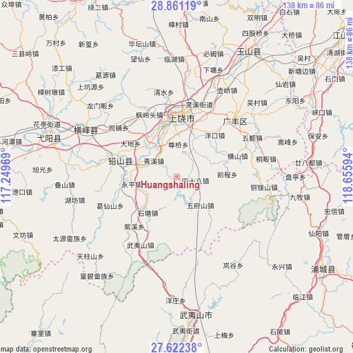
Huangshaling GPS coordinates[2]
28° 14' 36.888" North, 117° 57' 10.116" East
| Map corner | latitude | longitude |
|---|---|---|
| Upper-left | 28.86119°, | 117.24969° |
| Center: | 28.24358°, | 117.95281° |
| Lower-right: | 27.62238°, | 118.65594° |
| Map W x H: | 137.7×137.7 km | = 85.6×85.6mi |
| max Lat: | 53.31946° ⇑72% North |
| Huangshaling: | 28.24358° |
| min Lat: | ⇓28% South 18.22056° |
| min Long | Huangshaling | max Long |
| 75.07348° | 117.95281° | 134.28917° |
| W 70.4%⇐ | ⇒29.6% E |
Elevation
Elevation of Huangshaling is 147 m = 482 ft, and this is 337.8 m = 1108 ft below average elevation for this country.
| Max E: |
5622 m = 18445 ft | 52.4% |
| Avg. | 484.8 m = 1591 ft | |
| Huangshaling | 147 m = 482 ft | |
Min E: |
-3 m = -10 ft | 47.6% |
See also: China elevation on elevation.city.
Geographical zone
Huangshaling is located in North temperate zone (between Tropic of Cancer and the Arctic Circle). Distance of this Northern Tropic circle is 534.5 km =332.1 mi to South.| Distance of | km | miles | from Huangshaling |
|---|---|---|---|
| North Pole | 6866.7 | 4266.8 | to North |
| Arctic Circle | 4260.8 | 2647.5 | to North |
| Tropic Cancer | 534.5 | 332.1 | to South |
| Equator | 3140.4 | 1951.4 | to South |


Nearby cities:
15 places around Huangshaling: (largest is in red/bold)
• Bangluo
17 km =10.6 mi,  293°
293°
• Chating
14.1 km =8.8 mi,  333°
333°
• Dongtuan
19.3 km =12 mi, 328°
• Ehu
16.4 km =10.2 mi, 288°
• Gaozhou
17.5 km =10.9 mi,  137°
137°
• Jiaxuan
14 km =8.7 mi,  243°
243°
• Qingxi
11 km =6.8 mi,  307°
307°
• Shanglu
2.5 km =1.6 mi,  193°
193°
• Shitang
17.9 km =11.1 mi,  216°
216°
• Sishiba
7.5 km =4.7 mi,  101°
101°
• Tieshan
14.3 km =8.9 mi, 102°
• Wufushan
14.5 km =9 mi, 140°
• Xuri
21.5 km =13.4 mi,  351°
351°
• Yingjiang
12.3 km =7.6 mi,  198°
198°
• Yongping
17.4 km =10.8 mi,  259°
259°
Sources, notices
• [Note1] Compared only with cities in China existing in our database
• [Src1] Map data: © OpenStreetMap contributors (CC-BY-SA)
• [Src2] Other city data from geonames.org with taken over terms of usage.
• [Src3] Geographical zone / Annual Mean Temperature by Robert A. Rohde @ Wikipedia
