Qingxi geodata
Qingxi (Jiangxi) is a seat of a fourth-order administrative division; located in China in Asia/Shanghai (GMT+8) time zone. In our database, there are 1268 cities with bigger population. Compared to other cities in China, 71.4% of cities are located further ↑North; 70% of cities are located further ←West and 65.2% of cities have higher elevation than Qingxi. Note1


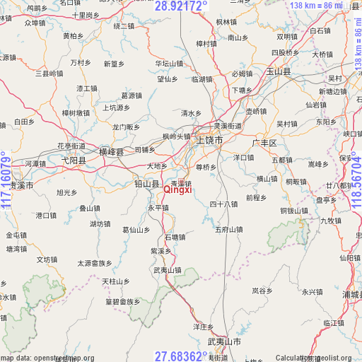
Qingxi GPS coordinates[2]
28° 18' 16.092" North, 117° 51' 50.076" East
| Map corner | latitude | longitude |
|---|---|---|
| Upper-left | 28.92172°, | 117.16079° |
| Center: | 28.30447°, | 117.86391° |
| Lower-right: | 27.68362°, | 118.56704° |
| Map W x H: | 137.7×137.7 km | = 85.6×85.6mi |
| max Lat: | 53.31946° ⇑71.4% North |
| Qingxi: | 28.30447° |
| min Lat: | ⇓28.6% South 18.22056° |
| min Long | Qingxi | max Long |
| 75.07348° | 117.86391° | 134.28917° |
| W 70%⇐ | ⇒30% E |
Elevation
Elevation of Qingxi is 72 m = 236 ft, and this is 412.8 m = 1354 ft below average elevation for this country.
| Max E: |
5622 m = 18445 ft | 65.2% |
| Avg. | 484.8 m = 1591 ft | |
| Qingxi | 72 m = 236 ft | |
Min E: |
-3 m = -10 ft | 34.8% |
See also: China elevation on elevation.city.
Geographical zone
Qingxi is located in North temperate zone (between Tropic of Cancer and the Arctic Circle). Distance of this Northern Tropic circle is 541.2 km =336.3 mi to South.| Distance of | km | miles | from Qingxi |
|---|---|---|---|
| North Pole | 6859.9 | 4262.5 | to North |
| Arctic Circle | 4254 | 2643.3 | to North |
| Tropic Cancer | 541.2 | 336.3 | to South |
| Equator | 3147.2 | 1955.6 | to South |


Nearby cities:
15 places around Qingxi: (largest is in red/bold)
• Bangluo
6.9 km =4.3 mi,  271°
271°
• Chating
6.3 km =3.9 mi,  22°
22°
• Dongtuan
9.8 km =6.1 mi,  351°
351°
• Ehu
7 km =4.3 mi,  257°
257°
• Fenglingtou
17.7 km =11 mi, 354°
• Hekou
15.3 km =9.5 mi, 274°
• Hongqiao
18.6 km =11.6 mi,  250°
250°
• Huangshaling
11 km =6.8 mi,  127°
127°
• Jiaxuan
13.5 km =8.4 mi,  196°
196°
• Shanglu
12.3 km =7.6 mi,  138°
138°
• Shangrao
18.1 km =11.2 mi,  25°
25°
• Sishiba
18 km =11.2 mi,  117°
117°
• Xintan
18.3 km =11.4 mi,  280°
280°
• Xuri
15.5 km =9.6 mi, 20°
• Yongping
13 km =8.1 mi,  220°
220°
Sources, notices
• [Note1] Compared only with cities in China existing in our database
• [Src1] Map data: © OpenStreetMap contributors (CC-BY-SA)
• [Src2] Other city data from geonames.org with taken over terms of usage.
• [Src3] Geographical zone / Annual Mean Temperature by Robert A. Rohde @ Wikipedia
