Shangrao geodata
Shangrao (Jiangxi) is a seat of a second-order administrative division; located in China in Asia/Shanghai (GMT+8) time zone. With population of 318,769 people, there are 173 cities with bigger population in this country. Compared to other cities in China, 70.1% of cities are located further ↑North; 70.3% of cities are located further ←West and 62.6% of cities have higher elevation than Shangrao. Note1


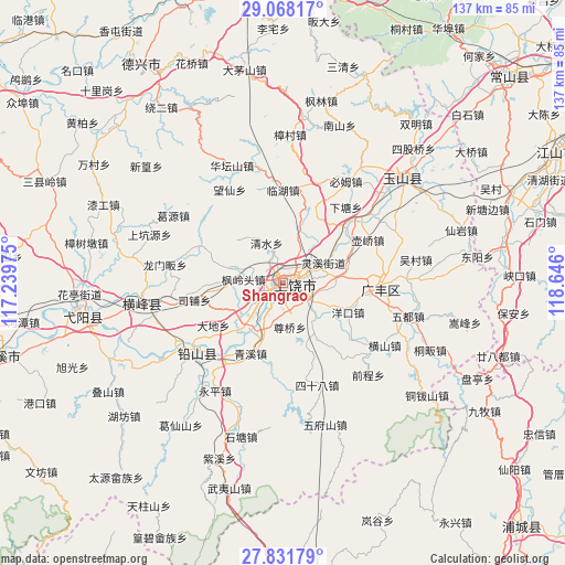
Shangrao GPS coordinates[2]
28° 27' 6.444" North, 117° 56' 34.332" East
| Map corner | latitude | longitude |
|---|---|---|
| Upper-left | 29.06817°, | 117.23975° |
| Center: | 28.45179°, | 117.94287° |
| Lower-right: | 27.83179°, | 118.646° |
| Map W x H: | 137.5×137.5 km | = 85.4×85.4mi |
| max Lat: | 53.31946° ⇑70.1% North |
| Shangrao: | 28.45179° |
| min Lat: | ⇓29.9% South 18.22056° |
| min Long | Shangrao | max Long |
| 75.07348° | 117.94287° | 134.28917° |
| W 70.3%⇐ | ⇒29.7% E |
Elevation
Elevation of Shangrao is 84 m = 276 ft, and this is 400.8 m = 1315 ft below average elevation for this country.
| Max E: |
5622 m = 18445 ft | 62.6% |
| Avg. | 484.8 m = 1591 ft | |
| Shangrao | 84 m = 276 ft | |
Min E: |
-3 m = -10 ft | 37.4% |
See also: Shangrao elevation on elevation.city.
Geographical zone
Shangrao is located in North temperate zone (between Tropic of Cancer and the Arctic Circle). Distance of this Northern Tropic circle is 557.6 km =346.5 mi to South.| Distance of | km | miles | from Shangrao |
|---|---|---|---|
| North Pole | 6843.5 | 4252.4 | to North |
| Arctic Circle | 4237.6 | 2633.1 | to North |
| Tropic Cancer | 557.6 | 346.5 | to South |
| Equator | 3163.5 | 1965.7 | to South |


Nearby cities:
15 places around Shangrao: (largest is in red/bold)
• Bangluo
21.8 km =13.5 mi,  221°
221°
• Chaoyang
12.4 km =7.7 mi,  94°
94°
• Chating
11.9 km =7.4 mi,  206°
206°
• Dongtuan
11.4 km =7.1 mi,  233°
233°
• Ehu
23.1 km =14.4 mi, 219°
• Fenglingtou
9.6 km =6 mi,  277°
277°
• Huanggu
14.8 km =9.2 mi,  14°
14°
• Lingxi
9.7 km =6 mi,  57°
57°
• Qingshui
11.9 km =7.4 mi,  331°
331°
• Qingxi
18.1 km =11.2 mi, 205°
• Shiren
23.1 km =14.4 mi,  349°
349°
• Shishi
6.3 km =3.9 mi,  28°
28°
• Sipu
23 km =14.3 mi,  265°
265°
• Wangcun
16.3 km =10.1 mi, 7°
• Xuri
2.9 km =1.8 mi, 230°
Sources, notices
• [Note1] Compared only with cities in China existing in our database
• [Src1] Map data: © OpenStreetMap contributors (CC-BY-SA)
• [Src2] Other city data from geonames.org with taken over terms of usage.
• [Src3] Geographical zone / Annual Mean Temperature by Robert A. Rohde @ Wikipedia
