Shishi geodata
Shishi (Jiangxi) is a seat of a fourth-order administrative division; located in China in Asia/Shanghai (GMT+8) time zone. In our database, there are 1268 cities with bigger population. Compared to other cities in China, 69.7% of cities are located further ↑North; 70.5% of cities are located further ←West and 57.7% of cities have higher elevation than Shishi. Note1


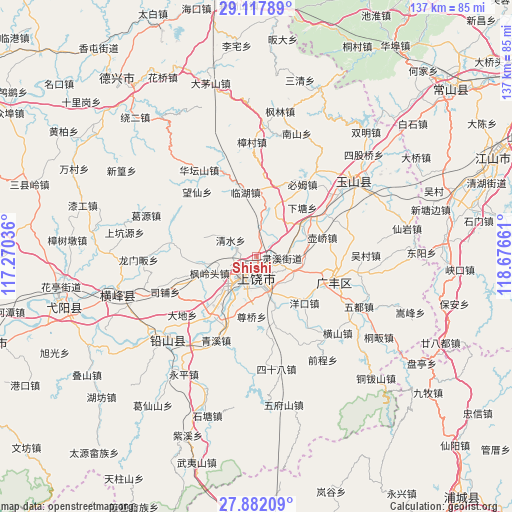
Shishi GPS coordinates[2]
28° 30' 6.48" North, 117° 58' 24.528" East
| Map corner | latitude | longitude |
|---|---|---|
| Upper-left | 29.11789°, | 117.27036° |
| Center: | 28.5018°, | 117.97348° |
| Lower-right: | 27.88209°, | 118.67661° |
| Map W x H: | 137.4×137.4 km | = 85.4×85.4mi |
| max Lat: | 53.31946° ⇑69.7% North |
| Shishi: | 28.5018° |
| min Lat: | ⇓30.3% South 18.22056° |
| min Long | Shishi | max Long |
| 75.07348° | 117.97348° | 134.28917° |
| W 70.5%⇐ | ⇒29.5% E |
Elevation
Elevation of Shishi is 113 m = 371 ft, and this is 371.8 m = 1220 ft below average elevation for this country.
| Max E: |
5622 m = 18445 ft | 57.7% |
| Avg. | 484.8 m = 1591 ft | |
| Shishi | 113 m = 371 ft | |
Min E: |
-3 m = -10 ft | 42.3% |
See also: China elevation on elevation.city.
Geographical zone
Shishi is located in North temperate zone (between Tropic of Cancer and the Arctic Circle). Distance of this Northern Tropic circle is 563.2 km =350 mi to South.| Distance of | km | miles | from Shishi |
|---|---|---|---|
| North Pole | 6838 | 4248.9 | to North |
| Arctic Circle | 4232.1 | 2629.7 | to North |
| Tropic Cancer | 563.2 | 350 | to South |
| Equator | 3169.1 | 1969.2 | to South |


Nearby cities:
15 places around Shishi: (largest is in red/bold)
• Chaoyang
11.4 km =7.1 mi,  124°
124°
• Chating
18.2 km =11.3 mi,  207°
207°
• Dongtuan
17.3 km =10.7 mi,  224°
224°
• Fenglingtou
13.2 km =8.2 mi,  251°
251°
• Huanggu
8.8 km =5.5 mi,  4°
4°
• Huqiao
18.7 km =11.6 mi,  73°
73°
• Lingxi
5.1 km =3.2 mi,  93°
93°
• Linhu
17.9 km =11.1 mi,  348°
348°
• Qingshui
9.9 km =6.2 mi,  299°
299°
• Shangrao
6.3 km =3.9 mi, 208°
• Shiren
18.7 km =11.6 mi,  336°
336°
• Wangcun
10.6 km =6.6 mi,  355°
355°
• Xiatang
17.6 km =10.9 mi,  44°
44°
• Xiaxi
21.4 km =13.3 mi,  102°
102°
• Xuri
9.1 km =5.7 mi, 215°
Sources, notices
• [Note1] Compared only with cities in China existing in our database
• [Src1] Map data: © OpenStreetMap contributors (CC-BY-SA)
• [Src2] Other city data from geonames.org with taken over terms of usage.
• [Src3] Geographical zone / Annual Mean Temperature by Robert A. Rohde @ Wikipedia
