Liuhu geodata
Liuhu (Jiangxi) is a seat of a fourth-order administrative division; located in China in Asia/Shanghai (GMT+8) time zone. In our database, there are 1268 cities with bigger population. Compared to other cities in China, 69.9% of cities are located further ↑North; 58.3% of cities are located further ←West and 80.2% of cities have higher elevation than Liuhu. Note1


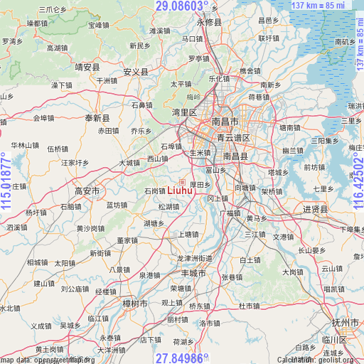
Liuhu GPS coordinates[2]
28° 28' 11.1" North, 115° 43' 18.804" East
| Map corner | latitude | longitude |
|---|---|---|
| Upper-left | 29.08603°, | 115.01877° |
| Center: | 28.46975°, | 115.72189° |
| Lower-right: | 27.84986°, | 116.42502° |
| Map W x H: | 137.4×137.5 km | = 85.4×85.4mi |
| max Lat: | 53.31946° ⇑69.9% North |
| Liuhu: | 28.46975° |
| min Lat: | ⇓30.1% South 18.22056° |
| min Long | Liuhu | max Long |
| 75.07348° | 115.72189° | 134.28917° |
| W 58.3%⇐ | ⇒41.7% E |
Elevation
Elevation of Liuhu is 26 m = 85 ft, and this is 458.8 m = 1505 ft below average elevation for this country.
| Max E: |
5622 m = 18445 ft | 80.2% |
| Avg. | 484.8 m = 1591 ft | |
| Liuhu | 26 m = 85 ft | |
Min E: |
-3 m = -10 ft | 19.8% |
See also: China elevation on elevation.city.
Geographical zone
Liuhu is located in North temperate zone (between Tropic of Cancer and the Arctic Circle). Distance of this Northern Tropic circle is 559.6 km =347.7 mi to South.| Distance of | km | miles | from Liuhu |
|---|---|---|---|
| North Pole | 6841.5 | 4251.1 | to North |
| Arctic Circle | 4235.6 | 2631.9 | to North |
| Tropic Cancer | 559.6 | 347.7 | to South |
| Equator | 3165.5 | 1966.9 | to South |


Nearby cities:
15 places around Liuhu: (largest is in red/bold)
• Dacheng
21.3 km =13.2 mi,  290°
290°
• Dongxin
16.8 km =10.4 mi,  37°
37°
• Fushan
13.8 km =8.6 mi,  68°
68°
• Gangshang
15 km =9.3 mi,  112°
112°
• Houtian
6.7 km =4.2 mi,  94°
94°
• Huangcheng
19.9 km =12.4 mi,  232°
232°
• Hutang
19.5 km =12.1 mi,  213°
213°
• Meilin
22.1 km =13.7 mi,  196°
196°
• Shangtang
19.8 km =12.3 mi,  176°
176°
• Shengmi
13.4 km =8.3 mi,  31°
31°
• Shigang
9.9 km =6.2 mi,  252°
252°
• Songhu
12.3 km =7.6 mi, 214°
• Tongtianxiang
17.6 km =10.9 mi,  150°
150°
• Wangcheng
23.4 km =14.5 mi,  14°
14°
• Xishan
13.2 km =8.2 mi,  313°
313°
Sources, notices
• [Note1] Compared only with cities in China existing in our database
• [Src1] Map data: © OpenStreetMap contributors (CC-BY-SA)
• [Src2] Other city data from geonames.org with taken over terms of usage.
• [Src3] Geographical zone / Annual Mean Temperature by Robert A. Rohde @ Wikipedia
